|
|
Antenna Structure Registration 1022392 |
 |
Registration Info | Registration Number: 1022392 |
| File Number: A1322695 |
| FAA Study: 2018-ANE-5609-OE |
| FAA Issue Date: 11/13/2018 |
| Status: Constructed |
| Date Constructed: 01/01/1965 |
| NEPA: N |
Structure Info
| Structure Type: GTOWER |
| Structure Coordinates: 41-49-38.9 N 71-22-7.2 W (NAD 83) |
| Structure Coordinates: 41-49-38.5 N 71-22-09.0 W (Converted to NAD 27) |
| Structure Address: 115 Eastern Ave / Us-ri-5001 |
| Structure City: East Providence, RI |
| Structure County: Providence County |
| Painting & Lighting Info |
FCC Paragraph(s): 1, 3, 4, 13, 21 |
Remarks: Continue As Is OM&L = PAINT/RED LIGHTS |
| Elevation Info |
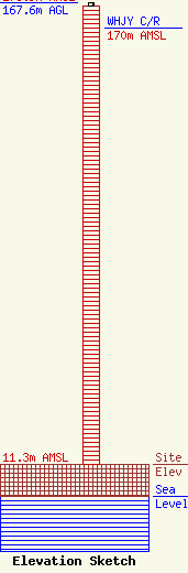
Site Elevation: 11.3 meters (37 ft) |
| Height of Structure: 166.6 meters (547 feet) |
| Overall Height Above Ground: 167.6 meters (550 feet) |
| Overall Height Above Mean Sea Level: 178.9 meters (587 feet) |
| WHJY C/R Height Above Mean Sea Level: 170 meters (558 ft)
|
| Owner Info | Vertical Bridge CC FM, LLC
22 W Atlantic Ave Suite 310
Delray Beach, FL 33444
(561) 405-4015
fcc-faa@verticalbridge.com |
| Contact Info | Vertical Bridge CC FM, LLC
22 W Atlantic Ave Suite 310
Delray Beach, FL 33444
Richard Hickey
(561) 405-4015
fcc-faa@verticalbridge.com |
