|
|
Antenna Structure Registration 1024374 |
 |
Registration Info | Registration Number: 1024374 |
| File Number: A0780463 |
| FAA Study: 02-ANE-210-OE |
| FAA Issue Date: 03/21/2002 |
| Status: Constructed |
| Date Constructed: 10/01/2004 |
| FAA EMI: N |
| NEPA: N |
Structure Info
| Structure Type: TOWER |
| Structure Coordinates: 42-20-9.0 N 71-42-55.0 W (NAD 83) |
| Structure Coordinates: 42-20-08.7 N 71-42-56.7 W (Converted to NAD 27) |
| Structure Address: Stiles Hill |
| Structure City: Boylston, MA |
| Structure County: Worcester County |
| Painting & Lighting Info |
FAA Circular #: 70/7460-1K |
FAA Chapters: 4, 7, 12 |
Remarks: PRIOR STUDY 01-ANE-0360-OE |
| Elevation Info |
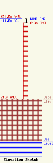
Site Elevation: 213 meters (699 ft) |
| Height of Structure: 391.8 meters (1285 feet) |
| Overall Height Above Ground: 411.5 meters (1350 feet) |
| Overall Height Above Mean Sea Level: 624.5 meters (2049 feet) |
| WUNI C/R Height Above Mean Sea Level: 613 meters (2011 ft)
|
| Owner Info | Entravision Communications Corporation
Suite 6000 West
Santa Monica, CA 90404
(310) 447-3870
mboelke@entravision.com |
| Contact Info | Thompson HIne LLP
Suite 700
Washington, DC 20036
Barry Friedman
(202) 331-8800
barry.friedman@thompsonhine.com |
