|
|
Antenna Structure Registration 1004484 |
 |
Registration Info | Registration Number: 1004484 |
| File Number: A1194691 |
| Status: Constructed |
| Date Constructed: 01/01/1974 |
| FAA EMI: N |
| NEPA: N |
Structure Info
| Structure Type: TOWER |
| Structure Coordinates: 42-5-5.0 N 72-42-12.0 W (NAD 83) |
| Structure Coordinates: 42-05-04.7 N 72-42-13.7 W (Converted to NAD 27) |
| Structure Address: 591 N West St |
| Structure City: Feeding Hills, MA |
| Structure County: Hampden County |
| Painting & Lighting Info |
FCC Paragraph(s): 1, 3, 4, 13, 21 |
| Elevation Info |
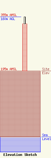
Site Elevation: 195 meters (640 ft) |
| Height of Structure: 139 meters (456 feet) |
| Overall Height Above Ground: 160 meters (525 feet) |
| Overall Height Above Mean Sea Level: 355 meters (1165 feet) |
| Owner Info | Nexstar Media Inc.
545 E. John Carpenter Freeway
Irving, TX 75062
(972) 373-8800
jasroberts@nexstar.tv |
| Contact Info | Nexstar Media Inc.
545 E. John Carpenter Freeway
Irving, TX 75062
Jason Roberts
(972) 373-8800
jasroberts@nexstar.tv |
