|
|
Antenna Structure Registration 1016021 |
 |
Registration Info | Registration Number: 1016021 |
| File Number: A1216158 |
| FAA Study: 2013-AWP-5435-OE |
| FAA Issue Date: 11/01/2013 |
| Status: Constructed |
| Date Constructed: 11/04/2013 |
| FAA EMI: N |
| NEPA: N |
Structure Info
| Structure Type: 3GTA3 |
| Structure Coordinates: 37-31-58.1 N 122-16-30.0 W (NAD 83) |
| Structure Coordinates: 37-31-58.3 N 122-16-26.1 W (Converted to NAD 27) |
| Structure Address: Twr 3 - E Side Of Bayshore Hwy |
| Structure City: San Mateo, CA |
| Structure County: San Mateo County |
| Painting & Lighting Info |
FAA Chapters: NONE |
| Elevation Info |
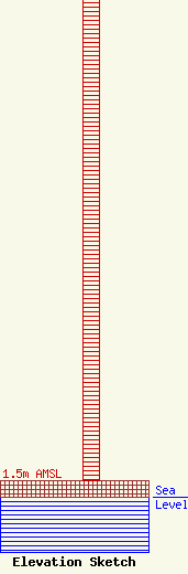
Site Elevation: 1.5 meters (5 ft) |
| Height of Structure: 46.9 meters (154 feet) |
| Overall Height Above Ground: 46.9 meters (154 feet) |
| Overall Height Above Mean Sea Level: 48.4 meters (159 feet) |
| Owner Info | Factorial Broadcasting, LLC
3774 Firpointe St.
San Ramon, CA 94582
(408) 718-3070
chandrasatish@yahoo.com |
| Contact Info | Wilkinson Barker Knauer, LLP
1800 M Street NW
Washington, DC 20036
David O'Connor
(202) 383-3429
doconnor@wbklaw.com |
