|
|
Antenna Structure Registration 1025308 |
 |
Registration Info | Registration Number: 1025308 |
| File Number: A1094558 |
| FAA Study: 94-AEA-0034-OE |
| FAA Issue Date: 07/06/1994 |
| Status: Granted |
| Date Constructed: 01/27/1994 |
| NEPA: N |
Structure Info
| Structure Type: LTOWER |
| Structure Coordinates: 40-34-18.0 N 75-25-45.6 W (NAD 83) |
| Structure Coordinates: 40-34-17.6 N 75-25-46.9 W (Converted to NAD 27) |
| Structure Address: 979 E Rock Rd |
| Structure City: Salisbury Township, PA |
| Structure County: Lehigh County |
| Painting & Lighting Info |
FAA Circular #: 70/7460-1H |
FAA Chapters: 3, 4, 5, 13 |
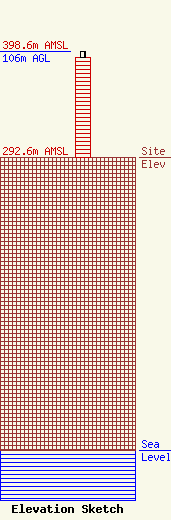
| Elevation Info |
Site Elevation: 292.6 meters (960 ft) |
| Height of Structure: 100 meters (328 feet) |
| Overall Height Above Ground: 106 meters (348 feet) |
| Overall Height Above Mean Sea Level: 398.6 meters (1308 feet) |
| Owner Info | INDUSTRIAL COMMUNICATIONS COMPANY
121 N SITGREAVES ST
EASTON, PA 18042
(610) 253-1214
cadams@icom-co.com |
| Contact Info | INDUSTRIAL COMMUNICATIONS COMPANY
121 N SITGREAVES ST
EASTON, PA 18042
Charles Adams
(610) 253-1214
cadams@icom-co.com |
