|
|
Antenna Structure Registration 1031820 |
 |
Registration Info | Registration Number: 1031820 |
| File Number: A1367627 |
| FAA Study: 97-AEA-2929-OE |
| Status: Constructed |
| Date Constructed: 01/01/1962 |
| FAA EMI: N |
| NEPA: N |
Structure Info
| Structure Type: TOWER |
| Structure Coordinates: 40-42-30.0 N 75-12-58.0 W (NAD 83) |
| Structure Coordinates: 40-42-29.6 N 75-12-59.4 W (Converted to NAD 27) |
| Structure Address: 107 Paxinosa Rd W |
| Structure City: Easton, PA |
| Structure County: Northampton County |
| Painting & Lighting Info |
FAA Circular #: 70/7460-1J |
FAA Chapters: 3, 4, 5, 13 |
| Elevation Info |
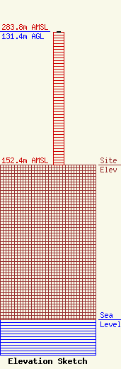
Site Elevation: 152.4 meters (500 ft) |
| Height of Structure: 130.5 meters (428 feet) |
| Overall Height Above Ground: 131.4 meters (431 feet) |
| Overall Height Above Mean Sea Level: 283.8 meters (931 feet) |
| Owner Info | Global Signal Acquisitions LLC
2000 Corporate Drive
Canonsburg, PA 15317
(724) 416-2400
Regulatory.Department@crowncastle.com |
| Contact Info | Crown Castle
2000 Corporate Drive
Canonsburg, PA 15317
Tom Anderson
(724) 743-6330
Tom.Anderson@crowncastle.com |
