|
|
Antenna Structure Registration 1049385 |
 |
Registration Info | Registration Number: 1049385 |
| File Number: A1369582 |
| FAA Study: 98-ASO-1150-OE |
| FAA Issue Date: 03/13/1998 |
| Status: Constructed |
| Date Constructed: 07/12/1998 |
| FAA EMI: N |
| NEPA: N |
Structure Info
| Structure Type: TOWER |
| Structure Coordinates: 34-55-22.0 N 85-19-1.0 W (NAD 83) |
| Structure Coordinates: 34-55-21.7 N 85-19-01.2 W (Converted to NAD 27) |
| Structure Address: 791 Mission Ridge Road |
| Structure City: Ft. Oglethorpe, GA |
| Structure County: Walker County |
| Painting & Lighting Info |
FAA Circular #: 70/7460-1J |
FAA Chapters: 4, 5, 6, 8, 13 |
Remarks: Removed expiration date from determination. Scenario 1./jjs/case#635066 |
| Elevation Info |
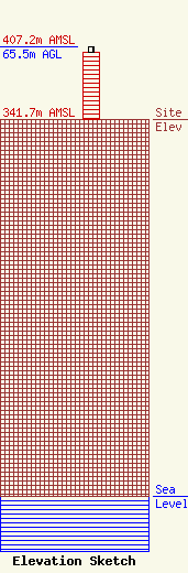
Site Elevation: 341.7 meters (1121 ft) |
| Height of Structure: 61 meters (200 feet) |
| Overall Height Above Ground: 65.5 meters (215 feet) |
| Overall Height Above Mean Sea Level: 407.2 meters (1336 feet) |
| Owner Info | Crown Castle Towers 06-2 LLC
2000 Corporate Drive
Canonsburg, PA 15317
(724) 416-2400
Regulatory.Department@crowncastle.com |
| Contact Info | |
