|
|
Antenna Structure Registration 1052337 |
 |
Registration Info | Registration Number: 1052337 |
| File Number: A1115953 |
| FAA Study: 2018-ASW-14533-OE |
| FAA Issue Date: 09/20/2018 |
| Status: Constructed |
| Date Constructed: 11/15/1978 |
| NEPA: N |
Structure Info
| Structure Type: GTOWER |
| Structure Coordinates: 33-29-37.7 N 101-44-2.7 W (NAD 83) |
| Structure Coordinates: 33-29-37.4 N 101-44-01.1 W (Converted to NAD 27) |
| Structure Address: 2 Miles Southeast On U. S. Hwy 84 (site # 204419) |
| Structure City: Lubbock, TX |
| Structure County: Lubbock County |
| Painting & Lighting Info |
Remarks: Continue As Is OM&L = PAINT/RED LIGHTS |
| Elevation Info |
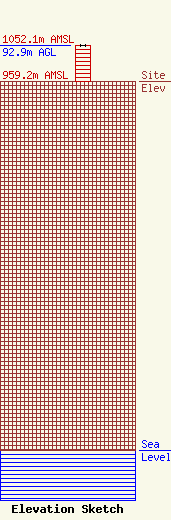
Site Elevation: 959.2 meters (3147 ft) |
| Height of Structure: 91.4 meters (300 feet) |
| Overall Height Above Ground: 92.9 meters (305 feet) |
| Overall Height Above Mean Sea Level: 1052.1 meters (3452 feet) |
| Owner Info | American Towers LLC
10 Presidential Way
Woburn, MA 01801
(781) 926-4500
faa-fcc@americantower.com |
| Contact Info | American Towers LLC
10 Presidential Way
Woburn, MA 01801
(781) 926-4500
faa-fcc@americantower.com |
