|
|
Antenna Structure Registration 1058483 |
 |
Registration Info | Registration Number: 1058483 |
| File Number: A1099150 |
| FAA Study: 98-ANE-237-OE |
| FAA Issue Date: 09/28/1998 |
| Status: Constructed |
| Date Constructed: 01/01/1980 |
| FAA EMI: N |
| NEPA: N |
Structure Info
| Structure Type: 5TA2 |
| Structure Coordinates: 42-14-50.0 N 71-25-32.0 W (NAD 83) |
| Structure Coordinates: 42-14-49.7 N 71-25-33.8 W (Converted to NAD 27) |
| Structure Address: Twr 2 - East End Of Sewell Street |
| Structure City: Ashland, MA |
| Structure County: Middlesex County |
| Painting & Lighting Info |
FAA Circular #: 70/7460-1J |
FAA Chapters: 3 |
Remarks: Removed expiration date from determination. Scenario 1./jjs/case#635066 |
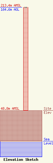
| Elevation Info |
Site Elevation: 48.8 meters (160 ft) |
| Height of Structure: 164.6 meters (540 feet) |
| Overall Height Above Ground: 164.6 meters (540 feet) |
| Overall Height Above Mean Sea Level: 213.4 meters (700 feet) |
| Owner Info | Gois Holdings Boston LLC
122 GREEN STREET
WORCESTER, MA 01604
(508) 791-2111
Pgois@goisbroadcasting.com |
| Contact Info | Gois Broadcasting Boston LLC
122 GREEN STREET
WORCESTER, MA 01604
Paul Gois
(508) 791-2111
Pgois@goisbroadcasting.com |
