|
|
Antenna Structure Registration 1058966 |
 |
Registration Info | Registration Number: 1058966 |
| File Number: A1030473 |
| FAA Study: 2007-ASO-2722-OE |
| FAA Issue Date: 06/19/2007 |
| Status: Constructed |
| Date Constructed: 05/05/1995 |
| FAA EMI: N |
| NEPA: N |
Structure Info
| Structure Type: MTOWER |
| Structure Coordinates: 34-44-1.0 N 86-43-43.0 W (NAD 83) |
| Structure Coordinates: 34-44-00.7 N 86-43-43.0 W (Converted to NAD 27) |
| Structure Address: 190 Stoneway Trail |
| Structure City: Madison, AL |
| Structure County: Madison County |
| Painting & Lighting Info |
FAA Chapters: NONE |
Remarks: PRIOR STUDY 2007-ASO-1036-OE |
| Elevation Info |
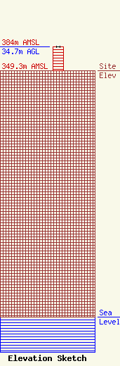
Site Elevation: 349.3 meters (1146 ft) |
| Height of Structure: 33.8 meters (111 feet) |
| Overall Height Above Ground: 34.7 meters (114 feet) |
| Overall Height Above Mean Sea Level: 384 meters (1260 feet) |
| Owner Info | CCATT LLC
2000 Corporate Drive
Canonsburg, PA 15317
(724) 416-2000
Regulatory.Department@Crowncastle.com |
| Contact Info | |
