|
|
Antenna Structure Registration 1209117 |
 |
Registration Info | Registration Number: 1209117 |
| File Number: A0218626 |
| FAA Study: 99-AEA-3982-OE |
| FAA Issue Date: 01/18/2000 |
| Status: Constructed |
| Date Constructed: 10/17/2001 |
| FAA EMI: N |
| NEPA: N |
Structure Info
| Structure Type: 6TA2 |
| Structure Coordinates: 39-22-26.8 N 76-51-30.4 W (NAD 83) |
| Structure Coordinates: 39-22-26.4 N 76-51-31.5 W (Converted to NAD 27) |
| Structure Address: 5280 Hernwood Road (intersection Of Hernwood And Marriottsville Roads) |
| Structure City: Randallstown, MD |
| Structure County: Baltimore County |
| Painting & Lighting Info |
FAA Chapters: NONE |
Remarks: PRIOR FAA 99-AEA-2655-OE |
Remarks: Removed expiration date from determination. Scenario 1./jjs/case#635066 |
Remarks: PRIOR FAA 99-AEA-2655-OE |
Remarks: Removed expiration date from determination. Scenario 1./jjs/case#635066 |
| Elevation Info |
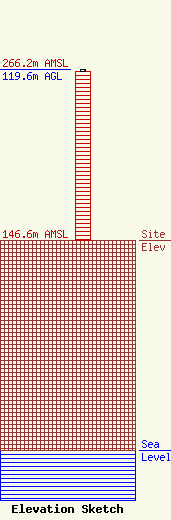
Site Elevation: 146.6 meters (481 ft) |
| Height of Structure: 118.6 meters (389 feet) |
| Overall Height Above Ground: 119.6 meters (392 feet) |
| Overall Height Above Mean Sea Level: 266.2 meters (873 feet) |
| Owner Info | WCBM Maryland, Inc.
1205 York Road #39C
Lutherville, MD 21093
(410) 825-8400
|
| Contact Info | WCBM Maryland Inc.
1205 York Road
Lutherville, MD 21093
Joe LaVerghetta
(410) 825-8400
|
