|
|
Antenna Structure Registration 1250360 |
 |
Registration Info | Registration Number: 1250360 |
| File Number: A1279131 |
| FAA Study: 2004-ASO-4005-OE |
| FAA Issue Date: 09/09/2004 |
| Status: Constructed |
| Date Constructed: 11/01/2005 |
| FAA EMI: N |
| NEPA: N |
Structure Info
| Structure Type: TOWER |
| Structure Coordinates: 32-36-1.6 N 85-29-52.6 W (NAD 83) |
| Structure Coordinates: 32-36-01.1 N 85-29-52.8 W (Converted to NAD 27) |
| Structure Address: 511 W. Samford Avenue (at1778) |
| Structure City: Auburn, AL |
| Structure County: Lee County |
| Painting & Lighting Info |
FAA Circular #: 70/7460-1K |
FAA Chapters: 4, 8, 12 |
Remarks: Removed expiration date from determination. Scenario 1./jjs/case#635066 |
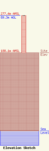
| Elevation Info |
Site Elevation: 188.1 meters (617 ft) |
| Height of Structure: 89.3 meters (293 feet) |
| Overall Height Above Ground: 89.3 meters (293 feet) |
| Overall Height Above Mean Sea Level: 277.4 meters (910 feet) |
| Owner Info | Auburn University OIT
300 LEM MORRISON DR.
AUBURN, AL 36849
(334) 734-4438
jam0046@auburn.edu |
| Contact Info | |
