
FCCInfo.com
A Service of Cavell, Mertz & Associates, Inc.
(855) FCC-INFO
|
|
K47JE-D from 01/26/2004 |
|
|
||||||||||||||||
|
|
Status: STA – Special Temporary Authority (Licensed And Silent) Application Accepted: 06/29/2021 STA Expires: 00/00/0000 File Number: -0000149729 FCC Website Links: LMS Facility Details This Application Other K47JE-D Applications Including Superseded Applications Mailing Address Correspondence for K47JE-D Correspondence related to application -0000149729 Service Contour - Open Street Map or USGS Map (51 dBu) Service Contour - KML / Google Earth (51 dBu) Rabbit Ears Info Search for K47JE-D Site Location: 44-45-32.9 N 94-52-24.0 W (NAD 83) Site Location: 44-45-33.0 N 94-52-23.0 W (Converted to NAD 27) ERP: 0.62 kW R/C AGL: 120.5 m (395 ft.) R/C AMSL: 453 m (1486 ft.) Emission Mask: Simple Site Elevation: 332.5 m. (1091 ft.) Height Overall*: 152.4 m (500 ft.) (* As Filed In This Application, may differ from ASR Data, Below.) Directional Antenna - Antenna Make/Model: Scala 4DR-8-2HW Antenna ID: 20751 | ||||||||||||||||||
| Antenna Data for Antenna Id: 20751 K47JE-D LD File: -0000149729 Scala - 4DR-8-2HW Service: LD Standard Pattern: Y | 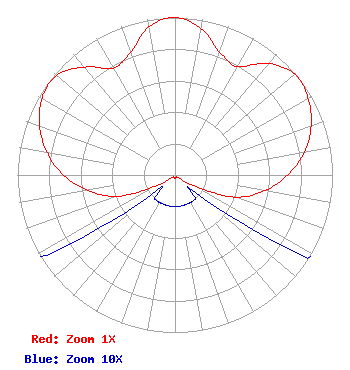 | ||||||||||||||||||
| Azimuth | Ratio | Azimuth | Ratio | Azimuth | Ratio | Azimuth | Ratio | ||||||||||||
| 0 | 1.000 | 10 | 0.945 | 20 | 0.830 | 30 | 0.795 | ||||||||||||
| 40 | 0.925 | 50 | 0.995 | 60 | 0.975 | 70 | 0.920 | ||||||||||||
| 80 | 0.835 | 90 | 0.715 | 100 | 0.580 | 110 | 0.410 | ||||||||||||
| 120 | 0.135 | 130 | 0.020 | 140 | 0.020 | 150 | 0.020 | ||||||||||||
| 160 | 0.020 | 170 | 0.020 | 180 | 0.020 | 190 | 0.020 | ||||||||||||
| 200 | 0.020 | 210 | 0.020 | 220 | 0.020 | 230 | 0.020 | ||||||||||||
| 240 | 0.130 | 250 | 0.395 | 260 | 0.560 | 270 | 0.710 | ||||||||||||
| 280 | 0.825 | 290 | 0.915 | 300 | 0.975 | 310 | 0.983 | ||||||||||||
| 320 | 0.895 | 330 | 0.784 | 340 | 0.827 | 350 | 0.955 | ||||||||||||
Structure Registration Number 1209827 Structure Type: TOWER Registered To: RENVILLE COUNTY TV CORPORATION Structure Address: 1.6 Km Ese Bird Island, MN County Name: Renville County ASR Issued: 02/23/2000 Date Built: 04/15/1975 Site Elevation: 332.5 m (1091 ft.) Structure Height: 152.4 m (500 ft.) Height Overall: 152.4 m (500 ft.) Overall Height AMSL: 484.9 m (1591 ft.) FAA Determination: 12/23/1999 FAA Study #: 99-AGL-6008-OE Paint & Light FAA Chapters: 1, 3, 4, 13, 21 PRIOR FAA # 99-TR-OOOO-OE CONTINUE OM&L PAINT/RED LIGHTS 44-45-32.9 N 94-52-24.0 W (NAD 83) 44-45-33.0 N 94-52-23.0 W (Converted to NAD 27) |
Hurst, TX 76054 Phone: 214-770-7770 Corporation | Title: Ceo Date: 06/29/2021 Application Certifier EDGE SPECTRUM, INC. Edge Spectrum, Inc. Hurst, TX 76054 Applicant Randy Weiss Edge Spectrum, Inc. Hurst, TX 76054 CEO Caleb Weiss Ark Multicasting, Inc. Cedar Hill, TX 75106 President Susan Hansen B. W. St. Clair 2305 Vida Shaw Rd. New Iberia, TX 70563 Consultant | |||||||||||||||||