FCCInfo.com
A Service of Cavell, Mertz & Associates, Inc.
(855) FCC-INFO
|
|
|
Virtual Channel 3 |  |
|
|||||||||||||||||||||||||||
|
|
Status: LIC Application Accepted: 08/04/2023 License Expires: 12/01/2028 File Number: 0000218937 FCC Website Links: LMS Facility Details This Application Other WWAY Applications Including Superseded Applications Mailing Address Correspondence for WWAY Correspondence related to application 0000218937 Service Contour - Open Street Map or USGS Map (41 dBu) Service Contour - KML / Google Earth (41 dBu) Public Inspection Files Rabbit Ears Info Search for WWAY Site Location: 34-07-54.0 N 78-11-16.0 W (NAD 83) Site Location: 34-07-53.4 N 78-11-17.0 W (Converted to NAD 27) ERP: 700 kW Polarization: Horizontally polarized HAAT: 592.2 m (1943 ft.) Electrical Beam Tilt: 1 degree R/C AGL: 588.2 m (1930 ft.) R/C AMSL: 607.4 m (1993 ft.) Site Elevation: 19.2 m. (63 ft.) Height Overall*: 595.6 m (1954 ft.) (* As Filed In This Application, may differ from ASR Data, Below.) Directional Antenna - Antenna Make/Model: Electronics Research Inc. ETU14U4-HTP4Ox-24/23/29 Antenna ID: 1010963 Polarization: Horizontally polarized | ||||||||||||||||||||||||||||||
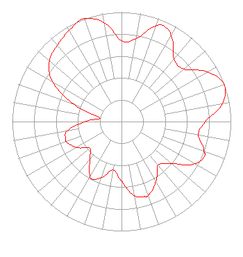
| Antenna Data for Antenna Id: 1010963 WWAY DT File: -0000218937 Electronics Research Inc. - ETU14U4-HTP4Ox-24/23/29 Service: DT Standard Pattern: N |  | ||||||||||||||||||||||||||||||
| Azimuth | Ratio | Azimuth | Ratio | Azimuth | Ratio | Azimuth | Ratio | ||||||||||||||||||||||||
| 0 | 0.739 | 10 | 0.768 | 20 | 0.927 | 24 | 0.956 | ||||||||||||||||||||||||
| 30 | 0.906 | 40 | 0.746 | 50 | 0.747 | 60 | 0.908 | ||||||||||||||||||||||||
| 70 | 0.999 | 80 | 0.937 | 90 | 0.767 | 100 | 0.714 | ||||||||||||||||||||||||
| 110 | 0.803 | 113 | 0.822 | 120 | 0.772 | 130 | 0.600 | ||||||||||||||||||||||||
| 140 | 0.521 | 150 | 0.631 | 160 | 0.715 | 163 | 0.717 | ||||||||||||||||||||||||
| 170 | 0.687 | 180 | 0.546 | 190 | 0.450 | 200 | 0.546 | ||||||||||||||||||||||||
| 207 | 0.590 | 210 | 0.573 | 220 | 0.449 | 230 | 0.378 | ||||||||||||||||||||||||
| 240 | 0.473 | 250 | 0.535 | 253 | 0.536 | 260 | 0.502 | ||||||||||||||||||||||||
| 270 | 0.333 | 280 | 0.200 | 290 | 0.465 | 300 | 0.728 | ||||||||||||||||||||||||
| 310 | 0.860 | 320 | 0.911 | 330 | 0.961 | 340 | 1.000 | ||||||||||||||||||||||||
| 350 | 0.918 | ||||||||||||||||||||||||||||||
Structure Registration Number 1008242 Structure Type: GTOWER Registered To: Brunswick County Tower, LLC Structure Address: 4.7 Km Ssw Of Int Of Sr 1410 & Sr 1413 Winnabow, NC County Name: Brunswick County ASR Issued: 05/13/2015 Date Built: 06/17/1981 Site Elevation: 19.2 m (63 ft.) Structure Height: 548 m (1798 ft.) Height Overall: 595.6 m (1954 ft.) Overall Height AMSL: 614.8 m (2017 ft.) FAA Determination: 12/06/2002 FAA Study #: 2002-ASO-6761-OE FAA Circular #: 70/7460-1 Paint & Light FAA Chapters: A1, B, G, H PRIOR STUDY 1996-ASO-2598-OE OM&L TO REMAIN 24 HR HI STROBES PER PRIOR STUDY 34-07-54.0 N 78-11-16.0 W (NAD 83) 34-07-53.4 N 78-11-17.0 W (Converted to NAD 27) |
301 Poplar Street Macon, GA 31201 Phone: 478-745-4141 Limited Liability Company | Title: Chief Operating Officer Date: 08/04/2023 Application Certifier WWAY-TV, LLC WWAY-TV, LLC 301 Poplar Street Macon, GA 31201 Applicant Anne Goodwin Crump Fletcher, Heald & Hildreth, P.L.C. 1300 North 17th Street Eleventh Floor Arlington, VA 22209 Joseph M. Davis, P.E. Chesapeake RF Consultants, LLC 207 Old Dominion Road Yorktown, VA 23692 Ray Luke Morris Network, Inc. 17363 Carlton Cuebas Rd Gulfport, MS 39503 | |||||||||||||||||||||||||||||
| |||||||||||||||||||||||||||||||