FCCInfo.com
A Service of Cavell, Mertz & Associates, Inc.
(855) FCC-INFO
|
|
|
Virtual Channel 17 |  |
|
|||||||||||||||||
|
|
Status: LIC Application Accepted: 06/23/2009 License Expires: 02/01/2029 File Number: BLCDT-20090623ABB Prefix Type: This is a License for a commercial digital TV station FCC Website Links: LMS Facility Details This Application Other WVXF Applications Including Superseded Applications Mailing Address Correspondence for WVXF Correspondence related to application BLCDT-20090623ABB Service Contour - Open Street Map or USGS Map (41 dBu) Service Contour - KML / Google Earth (41 dBu) Public Inspection Files Rabbit Ears Info Search for WVXF Site Location: 18-21-19.0 N 64-56-49.0 W (NAD 83) Site Location: 18-21-26.2 N 64-56-50.5 W (Converted to NAD 27) ERP: 4.2 kW Polarization: Horizontally polarized HAAT: 454 m (1490 ft.) R/C AGL: 18 m (59 ft.) R/C AMSL: 469 m (1539 ft.) Site Elevation: 451 m. (1480 ft.) Height Overall*: 35 m (115 ft.) (* As Filed In This Application, may differ from ASR Data, Below.) Directional Antenna - Antenna Make/Model: Propagation System Inc PSIUP2MC-17 Antenna ID: 87201 Polarization: Horizontally polarized | ||||||||||||||||||||
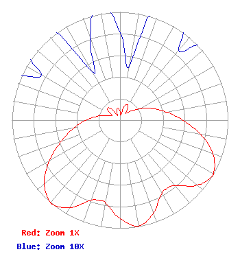
| Antenna Data for Antenna Id: 87201 WVXF DT File: BLCDT-20090623ABB Propagation System Inc - PSIUP2MC-17 Service: DT Standard Pattern: Y Pattern and Field Values Include a 170° Clockwise Rotation |  | ||||||||||||||||||||
| Azimuth | Ratio | Azimuth | Ratio | Azimuth | Ratio | Azimuth | Ratio | ||||||||||||||
| 0 | 0.081 | 10 | 0.052 | 20 | 0.147 | 30 | 0.150 | ||||||||||||||
| 40 | 0.084 | 50 | 0.129 | 60 | 0.209 | 70 | 0.313 | ||||||||||||||
| 80 | 0.436 | 90 | 0.582 | 100 | 0.757 | 110 | 0.917 | ||||||||||||||
| 120 | 0.998 | 121 | 1.000 | 130 | 0.936 | 140 | 0.791 | ||||||||||||||
| 146 | 0.768 | 150 | 0.780 | 160 | 0.910 | 170 | 0.994 | ||||||||||||||
| 180 | 0.910 | 190 | 0.780 | 194 | 0.768 | 200 | 0.791 | ||||||||||||||
| 210 | 0.936 | 219 | 1.000 | 220 | 0.998 | 230 | 0.917 | ||||||||||||||
| 240 | 0.757 | 250 | 0.582 | 260 | 0.436 | 270 | 0.313 | ||||||||||||||
| 280 | 0.209 | 290 | 0.129 | 300 | 0.084 | 310 | 0.150 | ||||||||||||||
| 320 | 0.147 | 330 | 0.052 | 340 | 0.081 | 350 | 0.116 | ||||||||||||||
Structure Registration Number 1024797 Structure Type: TOWER Registered To: VIRGIN ISLANDS PUBLIC TELEVISION SYSTEM Structure Address: Signal Hill Charlotte Amalie, VI County Name: St. Thomas Island ASR Issued: 08/07/1997 Date Built: 01/01/1972 Site Elevation: 451.1 m (1480 ft.) Structure Height: 30.5 m (100 ft.) Height Overall: 35.1 m (115 ft.) Overall Height AMSL: 486.2 m (1595 ft.) FAA Determination: 11/02/1985 FAA Study #: 85-SJU-37-OE Paint & Light FAA Chapters: 1, 2 RED LIGHTS/PAINT 18-21-19.0 N 64-56-49.0 W (NAD 83) 18-21-26.2 N 64-56-50.5 W (Converted to NAD 27) |
6380 Wilshire Blvd. Suite 1604 Los Angeles, CA 90048 Phone: 323-930-1908 Limited Liability Company | Date: 06/23/2009 Application Certifier Storefront Television, LLC Building 25, Third Floor 1040 N. Las Palmas Hollywood, CA 90038 Applicant Donald J. Baad PO Box 220 Coldwater, MI 49036 Consulting Engineer Joan Stewart, Esq. Wiley Rein LLP 1776 K Street, NW Washington, DC 20006 | |||||||||||||||||||