
FCCInfo.com
A Service of Cavell, Mertz & Associates, Inc.
(855) FCC-INFO
|
|
K268BN from 05/25/2006 K268BN from 04/29/1999 K268BN from 10/30/1998 |
|
|
||||||||||||||||
|
|
K268BN Channel: 268D 101.5 MHz Eufaula/longview, Washington Service: FX - A translator or application for a translator. Facility ID: 91970 Fac. Service: FX Programming Delivery Method: Unspecified Status: License Application Accepted: 10/06/2009 Application Granted: 10/28/2009 File Number: BLFT-20091006ADQ Prefix Type: This is a license for a translator Application Type: License To Cover FCC Website Links: LMS Facility Details This Application CDBS Application Other K268BN Applications Other K268BN Applications in CDBS Including Superseded Applications Mailing Address Correspondence for K268BN Correspondence related to application BLFT-20091006ADQ Service Contour - Open Street Map or USGS Map (60 dBu) Service Contour - KML / Google Earth (60 dBu) Class: D, A Noncommercial educational operating with no more than 10W Site Location: 46-09-50.4 N 122-51-16.4 W (NAD 83) Site Location: 46-09-51.0 N 122-51-12.0 W (Converted to NAD 27) Effective Radiated Power: 0.25 kW Transmitter Output Power: 0.077 kW Antenna Center HAAT: 266.6 m Horiz.; 0 m Vert. Antenna Center AMSL: 447 m (1467 ft.) Antenna Center HAG: 35 m (115 ft.) Site Elevation: 412 m. (1352 ft.) Height Overall*: 49 m (161 ft.) (* As Filed In This Application, may differ from ASR Data, Below.) Directional Antenna Antenna Make/Model: None Antenna ID: 91943 Polarization:
| ||||||||||||||||||
| Antenna Data for Antenna Id: 91943 K268BN FX File: BLFT-20091006ADQ None - Service: FX | 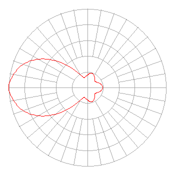 | ||||||||||||||||||
| Azimuth | Ratio | Azimuth | Ratio | Azimuth | Ratio | Azimuth | Ratio | ||||||||||||
| 0 | 0.157 | 10 | 0.181 | 20 | 0.187 | 30 | 0.171 | ||||||||||||
| 40 | 0.140 | 50 | 0.123 | 60 | 0.135 | 70 | 0.160 | ||||||||||||
| 80 | 0.182 | 90 | 0.193 | 100 | 0.182 | 110 | 0.160 | ||||||||||||
| 120 | 0.135 | 130 | 0.123 | 140 | 0.140 | 150 | 0.171 | ||||||||||||
| 160 | 0.187 | 170 | 0.181 | 180 | 0.157 | 190 | 0.142 | ||||||||||||
| 200 | 0.134 | 210 | 0.190 | 220 | 0.329 | 230 | 0.528 | ||||||||||||
| 240 | 0.718 | 250 | 0.866 | 260 | 0.952 | 270 | 1.000 | ||||||||||||
| 280 | 0.952 | 290 | 0.866 | 300 | 0.718 | 310 | 0.528 | ||||||||||||
| 320 | 0.329 | 330 | 0.190 | 340 | 0.134 | 350 | 0.142 | ||||||||||||
Structure Registration Number 1268455 Structure Type: TOWER Registered To: Longview Timberlands LLC Structure Address: Mt. Brynion Road, 3 Miles East Of Kelso Kelso, WA County Name: Cowlitz County ASR Issued: 05/23/2009 Date Built: 01/01/1975 Site Elevation: 411.8 m (1351 ft.) Structure Height: 48.8 m (160 ft.) Height Overall: 48.8 m (160 ft.) Overall Height AMSL: 460.6 m (1511 ft.) FAA Determination: 04/13/2009 FAA Study #: 2009-anm-622-oe Paint & Light FAA Chapters: NONE 46-09-50.4 N 122-51-16.4 W (NAD 83) 46-09-51.0 N 122-51-12.0 W (Converted to NAD 27) |
Po Box 90 Kelso, WA 98626 Phone: 360-636-0110 | Date: 10/06/2009 Application Certifier WASHINGTON INTERSTATE BROADCASTING COMPANY, INC. Po Box 90 Kelso, WA 98626 Applicant JOHN J. MULLANEY Mullaney Engineering, Inc. 9049 Shady Grove Court Gaithersburg, MD 20877 CONSULTING ENGINEER RICHARD J. HAYES, JR. Attorney At Law 27 Waters Edge Drive Lincolnville, ME 04849 | |||||||||||||||||