
FCCInfo.com
A Service of Cavell, Mertz & Associates, Inc.
(855) FCC-INFO
|
|
WBEY-FM from 08/18/1995 |
|
|
||||||||||||||||
|
|
WBEY-FM Channel: 250A 97.9 MHz Crisfield, Maryland Service: FM - A full-service FM station or application. Facility ID: 27438 Fac. Service: FM Analog & Digital Status: License 73.215 Station Application Accepted: 03/30/2005 Application Granted: 04/15/2005 File Number: BLH-20050330AJM License Expires: 00/00/0000 Prefix Type: This is a license for a commercial FM station Application Type: Amendment FCC Website Links: LMS Facility Details This Application CDBS Application Other WBEY-FM Applications Other WBEY-FM Applications in CDBS Including Superseded Applications Mailing Address Correspondence for WBEY-FM Correspondence related to application BLH-20050330AJM Service Contour - Open Street Map or USGS Map (60 dBu) Service Contour - KML / Google Earth (60 dBu) Public Inspection Files Facility Type: FM STATION Class: A, A Zone I; I-A; or II station; with 0.1kW-6kW ERP and a class contour distance <=28km Site Location: 38-01-45.4 N 75-45-03.7 W (NAD 83) Site Location: 38-01-45.0 N 75-45-05.0 W (Converted to NAD 27) Effective Radiated Power: 4.3 kW Transmitter Output Power: 4.083 kW Antenna Center HAAT: 115.6 m (379 ft.) Antenna Center AMSL: 116.4 m (382 ft.) Antenna Center HAG: 114.3 m (375 ft.) Calculated Site Elevation: 2.1 m. (7 ft.) Height Overall*: 142.6 m (468 ft.) (* As Filed In This Application, may differ from ASR Data, Below.) Directional Antenna Antenna Make/Model: DIELECTRIC DCRH4E5, four sections, 0.5 wavelength spacing Antenna ID: 68233 Polarization:
| ||||||||||||||||||
| Antenna Data for Antenna Id: 68233 WBEY-FM FM File: BLH-20050330AJM DIELECTRIC - DCRH4E5, four sections, 0.5 wavelength spacing Service: FM | 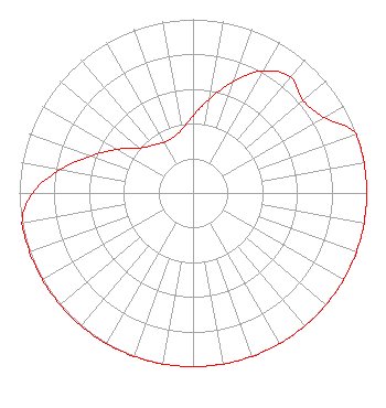 | ||||||||||||||||||
| Azimuth | Ratio | Azimuth | Ratio | Azimuth | Ratio | Azimuth | Ratio | ||||||||||||
| 0 | 0.442 | 10 | 0.550 | 20 | 0.684 | 30 | 0.813 | ||||||||||||
| 40 | 0.871 | 50 | 0.828 | 60 | 0.871 | 70 | 1.000 | ||||||||||||
| 80 | 1.000 | 90 | 1.000 | 100 | 1.000 | 110 | 1.000 | ||||||||||||
| 120 | 1.000 | 130 | 1.000 | 140 | 1.000 | 150 | 1.000 | ||||||||||||
| 160 | 1.000 | 170 | 1.000 | 180 | 1.000 | 190 | 1.000 | ||||||||||||
| 200 | 1.000 | 210 | 1.000 | 220 | 1.000 | 230 | 1.000 | ||||||||||||
| 240 | 1.000 | 250 | 1.000 | 260 | 1.000 | 270 | 0.925 | ||||||||||||
| 280 | 0.778 | 290 | 0.625 | 300 | 0.502 | 310 | 0.403 | ||||||||||||
| 320 | 0.359 | 330 | 0.337 | 340 | 0.339 | 350 | 0.372 | ||||||||||||
Structure Registration Number 1202432 [ASR Heights Differ from WBEY-FM Application] Structure Type: GTOWER Registered To: Pinnacle Towers Acquisition LLC Structure Address: 28927 Iren Whittington Road Marion Station, MD County Name: Somerset County ASR Issued: 04/03/2019 Date Built: 08/16/2001 Site Elevation: 2.1 m (7 ft.) Structure Height: 137.2 m (450 ft.) Height Overall: 144.2 m (473 ft.) Overall Height AMSL: 146.3 m (480 ft.) FAA Determination: 03/29/2019 FAA Study #: 2018-AEA-13041-OE FAA Circular #: 70/7460-1K Paint & Light FAA Chapters: 4, 8, 12 OM&L to remain the same as prior study = A MED-DUAL SYSTEM 38-01-44.5 N 75-45-04.0 W (NAD 83) 38-01-44.1 N 75-45-05.3 W (Converted to NAD 27) |
6139 Franklin Park Road Mclean, VA 22101 Phone: 703-489-5004 Limited Liability Company | Date: 03/30/2005 Application Certifier BAY BROADCASTING, INC. 1637 Dun Swamp Rd Pocomoke City, MD 21851-3300 Applicant TERRY J. DALTON 30708 River Road Laurel, DE 19956 CONSULTANT BARRY A. FRIEDMAN, ESQ. Thompson Hine Llp | |||||||||||||||||
| |||||||||||||||||||