
FCCInfo.com
A Service of Cavell, Mertz & Associates, Inc.
(855) FCC-INFO
|
|
WRJK-LD from 01/18/2013 WRJK-LD from 04/26/2001 WRJK-LD from 05/27/1987 |
|
|
||||||||||||||||
|
|
Status: Construction Permit Application Accepted: 02/11/2014 WRJK-LD CP Expires: 12/01/2021 File Number: BMPDTL-20140211ACV Prefix Type: This is BMPDTL FCC Website Links: LMS Facility Details This Application Other WRJK-LD Applications Including Superseded Applications Mailing Address Correspondence for WRJK-LD Correspondence related to application BMPDTL-20140211ACV Service Contour - Open Street Map or USGS Map (51 dBu) Service Contour - KML / Google Earth (51 dBu) Rabbit Ears Info Search for WRJK-LD Site Location: 41-52-44.0 N 87-38-08.0 W (NAD 83) Site Location: 41-52-43.9 N 87-38-07.8 W (Converted to NAD 27) ERP: 15 kW R/C AGL: 455 m (1493 ft.) R/C AMSL: 636.4 m (2088 ft.) Emission Mask: Full Service Site Elevation: 181.4 m. (595 ft.) Height Overall*: 521.1 m (1710 ft.) (* As Filed In This Application, may differ from ASR Data, Below.) Directional Antenna - Antenna Make/Model: ALI ATC-BCE710C3SR-24 Antenna ID: 117753 | ||||||||||||||||||
| Antenna Data for Antenna Id: 117753 WRJK-LD LD File: BMPDTL-20140211ACV ALI - ATC-BCE710C3SR-24 Service: LD Standard Pattern: Y Pattern and Field Values Include a 240° Clockwise Rotation | 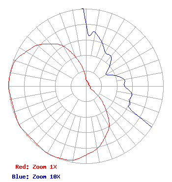 | ||||||||||||||||||
| Azimuth | Ratio | Azimuth | Ratio | Azimuth | Ratio | Azimuth | Ratio | ||||||||||||
| 0 | 0.080 | 10 | 0.070 | 20 | 0.060 | 30 | 0.050 | ||||||||||||
| 40 | 0.050 | 50 | 0.040 | 60 | 0.030 | 70 | 0.040 | ||||||||||||
| 80 | 0.050 | 90 | 0.050 | 100 | 0.060 | 110 | 0.060 | ||||||||||||
| 120 | 0.080 | 130 | 0.230 | 140 | 0.400 | 150 | 0.600 | ||||||||||||
| 160 | 0.710 | 170 | 0.820 | 180 | 0.890 | 190 | 0.970 | ||||||||||||
| 200 | 0.990 | 210 | 1.000 | 220 | 0.980 | 230 | 0.980 | ||||||||||||
| 240 | 1.000 | 250 | 0.980 | 260 | 0.980 | 270 | 1.000 | ||||||||||||
| 280 | 0.990 | 290 | 0.970 | 300 | 0.890 | 310 | 0.820 | ||||||||||||
| 320 | 0.710 | 330 | 0.600 | 340 | 0.400 | 350 | 0.230 | ||||||||||||
Structure Registration Number 1032960 [ASR Heights Differ from WRJK-LD Application] Structure Type: BMAST Registered To: BRE 312 Broadcast, LLC Structure Address: 233 South Wacker Drive Chicago, IL County Name: Cook County ASR Issued: 02/03/2019 Date Built: 09/30/2012 Site Elevation: 181.4 m (595 ft.) Structure Height: 437.5 m (1435 ft.) Height Overall: 524.9 m (1722 ft.) Overall Height AMSL: 706.3 m (2317 ft.) FAA Determination: 07/09/2012 FAA Study #: 2012-AGL-4496-OE FAA Circular #: 70/7460-1K Paint & Light FAA Chapters: 4, 7, 12 PRIOR STUDY 1999-AGL-4838-OE 41-52-44.0 N 87-38-08.0 W (NAD 83) 41-52-43.9 N 87-38-07.8 W (Converted to NAD 27) |
2383 Pruneridge Ave Suite 4 Santa Clara, CA 95050 Phone: 415-886-7284 Limited Liability Company | Date: 02/11/2014 Application Certifier CHICAGO 22, LLC 1640 Alum Rock Avenue San Jose, CA 95116-2429 Applicant B. W. ST. CLAIR 2355 Ranch Drive Westminster, CO 80234 ENGINEERING CONSULTANT PETER TANNENWALD Fletcher, Heald & Hildreth, P.l.c. 1300 North 17th St. 11th Floor Arlington, VA 22209-3801 | |||||||||||||||||