
FCCInfo.com
A Service of Cavell, Mertz & Associates, Inc.
(855) FCC-INFO
|
|
K31KW-D from 01/22/1992 |
|
|
||||||||||||||||
|
|
Status: License Application Accepted: 04/03/2012 License Expires: 02/01/2023 File Number: BLDTL-20120403ACG Prefix Type: This is BLDTL FCC Website Links: LMS Facility Details This Application Other K31KW-D Applications Including Superseded Applications Mailing Address Correspondence for K31KW-D Correspondence related to application BLDTL-20120403ACG Service Contour - Open Street Map or USGS Map (51 dBu) Service Contour - KML / Google Earth (51 dBu) Rabbit Ears Info Search for K31KW-D Site Location: 46-14-03.6 N 119-19-17.4 W (NAD 83) Site Location: 46-14-04.1 N 119-19-13.3 W (Converted to NAD 27) ERP: 6.01 kW R/C AGL: 27 m (89 ft.) R/C AMSL: 511.6 m (1678 ft.) Emission Mask: Stringent Site Elevation: 484.6 m. (1590 ft.) Height Overall*: 46.9 m (154 ft.) (* As Filed In This Application, may differ from ASR Data, Below.) Directional Antenna - Antenna Make/Model: Jampro JASSFULLCARDIOID-8 Antenna ID: 96296 | ||||||||||||||||||
| Antenna Data for Antenna Id: 96296 K31KW-D LD File: BLDTL-20120403ACG Jampro - JASSFULLCARDIOID-8 Service: LD Standard Pattern: Y Pattern and Field Values Include a 280° Clockwise Rotation | 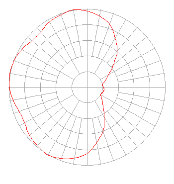 | ||||||||||||||||||
| Azimuth | Ratio | Azimuth | Ratio | Azimuth | Ratio | Azimuth | Ratio | ||||||||||||
| 0 | 0.970 | 10 | 0.920 | 20 | 0.850 | 30 | 0.720 | ||||||||||||
| 40 | 0.600 | 50 | 0.440 | 60 | 0.320 | 70 | 0.250 | ||||||||||||
| 80 | 0.200 | 90 | 0.210 | 100 | 0.220 | 110 | 0.210 | ||||||||||||
| 120 | 0.200 | 130 | 0.250 | 140 | 0.320 | 150 | 0.440 | ||||||||||||
| 160 | 0.600 | 170 | 0.720 | 180 | 0.850 | 190 | 0.920 | ||||||||||||
| 200 | 0.970 | 210 | 1.000 | 220 | 0.980 | 230 | 0.960 | ||||||||||||
| 240 | 0.920 | 250 | 0.920 | 260 | 0.960 | 270 | 0.990 | ||||||||||||
| 280 | 1.000 | 290 | 0.990 | 300 | 0.960 | 310 | 0.920 | ||||||||||||
| 320 | 0.920 | 330 | 0.960 | 340 | 0.980 | 350 | 1.000 | ||||||||||||
Structure Registration Number 1028315 Structure Type: TOWER Registered To: Global Tower, LLC. through American Towers, LLC Structure Address: 2.9 Km W Of Intersection Of Keene And Brantingham Kennewick, WA County Name: Benton County ASR Issued: 08/29/2014 Date Built: 04/01/1995 Site Elevation: 484.6 m (1590 ft.) Structure Height: 46.9 m (154 ft.) Height Overall: 46.9 m (154 ft.) Overall Height AMSL: 531.5 m (1744 ft.) FAA Determination: 04/22/2009 FAA Study #: 2009-ANM-614-OE Paint & Light FAA Chapters: NONE PRIOR STUDY 1997-ANM-547-OE 46-14-03.6 N 119-19-17.4 W (NAD 83) 46-14-04.1 N 119-19-13.3 W (Converted to NAD 27) |
Po Box 220 West Frankfort, IL 62896 Phone: 618-627-4651 Not-for-Profit | Date: 04/03/2012 Application Certifier THREE ANGELS BROADCASTING NETWORK, INC. P O Box 220 West Frankfort, IL 62896-0220 Applicant DANIEL N. PEEK Po Box 220 West Frankfort, IL 62896-0220 ENGINEER MOSES PRIMO 3abn | |||||||||||||||||