
FCCInfo.com
A Service of Cavell, Mertz & Associates, Inc.
(855) FCC-INFO
|
|
|
|
|
||||||||||||||||
|
|
Status: License Application Accepted: 11/02/2010 License Expires: 10/01/2021 File Number: BLDVL-20101102ACM Prefix Type: This is BLDVL FCC Website Links: LMS Facility Details This Application Other WCDN-LD Applications Including Superseded Applications Mailing Address Correspondence for WCDN-LD Correspondence related to application BLDVL-20101102ACM Service Contour - Open Street Map or USGS Map (48 dBu) Service Contour - KML / Google Earth (48 dBu) Rabbit Ears Info Search for WCDN-LD Site Location: 41-23-02.0 N 81-41-43.0 W (NAD 83) Site Location: 41-23-01.8 N 81-41-43.5 W (Converted to NAD 27) ERP: 0.3 kW Electrical Beam Tilt: 0.5 degrees R/C AGL: 251.5 m (825 ft.) R/C AMSL: 531.3 m (1743 ft.) Emission Mask: Stringent Site Elevation: 279.8 m. (918 ft.) Height Overall*: 344.7 m (1131 ft.) (* As Filed In This Application, may differ from ASR Data, Below.) Directional Antenna - Antenna Make/Model: Bogner B4UA Antenna ID: 18122 | ||||||||||||||||||
| Antenna Data for Antenna Id: 18122 WCDN-LD LD File: BLDVL-20101102ACM Bogner - B4UA Service: LD Standard Pattern: Y Pattern and Field Values Include a 160° Clockwise Rotation | 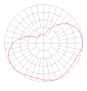 | ||||||||||||||||||
| Azimuth | Ratio | Azimuth | Ratio | Azimuth | Ratio | Azimuth | Ratio | ||||||||||||
| 0 | 0.220 | 10 | 0.230 | 20 | 0.350 | 30 | 0.470 | ||||||||||||
| 40 | 0.630 | 50 | 0.775 | 60 | 0.875 | 70 | 0.950 | ||||||||||||
| 80 | 0.980 | 90 | 1.000 | 100 | 0.975 | 110 | 0.940 | ||||||||||||
| 120 | 0.920 | 130 | 0.925 | 140 | 0.950 | 150 | 0.970 | ||||||||||||
| 160 | 1.000 | 170 | 0.970 | 180 | 0.950 | 190 | 0.925 | ||||||||||||
| 200 | 0.920 | 210 | 0.940 | 220 | 0.975 | 230 | 1.000 | ||||||||||||
| 240 | 0.980 | 250 | 0.950 | 260 | 0.875 | 270 | 0.775 | ||||||||||||
| 280 | 0.630 | 290 | 0.470 | 300 | 0.350 | 310 | 0.230 | ||||||||||||
| 320 | 0.220 | 330 | 0.225 | 340 | 0.230 | 350 | 0.225 | ||||||||||||
Structure Registration Number 1012028 Structure Type: TOWER Registered To: K2 Towers II, LLC Structure Address: 2855 W Ridgewood Dr Parma, OH County Name: Cuyahoga County ASR Issued: 10/13/2022 Date Built: 03/30/1993 Site Elevation: 279.8 m (918 ft.) Structure Height: 343.8 m (1128 ft.) Height Overall: 344.7 m (1131 ft.) Overall Height AMSL: 624.5 m (2049 ft.) FAA Determination: 01/09/1992 FAA Study #: 90-AGL-1665-OE FAA Circular #: 70/7460-1H Paint & Light FAA Chapters: 3, 4, 5, 13 41-23-02.0 N 81-41-43.0 W (NAD 83) 41-23-01.8 N 81-41-43.5 W (Converted to NAD 27) |
3901 Highway 121 South Bedford, TX 76021 Phone: 817-571-1229 Not-for-Profit | Date: 11/02/2010 Application Certifier WORD OF GOD FELLOWSHIP, INC. 3901 Highway 121 South Bedford, TX 76021 Applicant RICHARD C GOETZ 135 N Country Club Dr Hendersonville, TN 37075 BROADCAST CONSULTANT ARNOLD TORRES Word Of God Fellowship, Inc. | |||||||||||||||||