
FCCInfo.com
A Service of Cavell, Mertz & Associates, Inc.
(855) FCC-INFO
|
|
KQEG-CD from 08/28/2001 KQEG-CD from 02/05/1996 KQEG-CD from 07/15/1992 |
|  |
|
|||||||||||||||
|
|
Repacking Information: No changes Status: License Application Accepted: 05/20/2015 License Expires: 04/01/2022 File Number: -0000001542 FCC Website Links: LMS Facility Details This Application Other KQEG-CD Applications Including Superseded Applications Mailing Address Correspondence for KQEG-CD Correspondence related to application -0000001542 Service Contour - Open Street Map or USGS Map (51 dBu) Service Contour - KML / Google Earth (51 dBu) Public Inspection Files Rabbit Ears Info Search for KQEG-CD Site Location: 43-44-53.0 N 91-17-51.0 W (NAD 83) Site Location: 43-44-53.1 N 91-17-50.5 W (Converted to NAD 27) ERP: 15 kW Polarization: Horizontally polarized Electrical Beam Tilt: 1.5 degrees R/C AGL: 137 m (449 ft.) R/C AMSL: 492.0 m (1614 ft.) Emission Mask: Simple Site Elevation: 355 m. (1165 ft.) Height Overall*: 152 m (499 ft.) (* As Filed In This Application, may differ from ASR Data, Below.) Directional Antenna - Antenna Make/Model: Systems With Reliability Inc. SWLP16ECR/23 Antenna ID: 94741 Polarization: Horizontally polarized | ||||||||||||||||||
| Antenna Data for Antenna Id: 94741 KQEG-CD DC File: -0000001542 Systems With Reliability Inc. - SWLP16ECR/23 Service: DC Standard Pattern: Y Pattern and Field Values Include a 30° Clockwise Rotation | 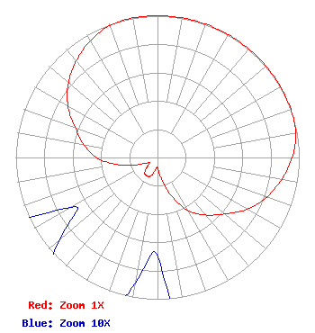 | ||||||||||||||||||
| Azimuth | Ratio | Azimuth | Ratio | Azimuth | Ratio | Azimuth | Ratio | ||||||||||||
| 0 | 1.000 | 10 | 1.000 | 20 | 1.000 | 30 | 1.000 | ||||||||||||
| 40 | 1.000 | 50 | 1.000 | 60 | 1.000 | 70 | 1.000 | ||||||||||||
| 80 | 0.990 | 90 | 0.950 | 100 | 0.890 | 110 | 0.820 | ||||||||||||
| 120 | 0.730 | 130 | 0.620 | 140 | 0.530 | 150 | 0.430 | ||||||||||||
| 160 | 0.290 | 170 | 0.150 | 180 | 0.070 | 190 | 0.090 | ||||||||||||
| 200 | 0.140 | 210 | 0.150 | 220 | 0.140 | 230 | 0.090 | ||||||||||||
| 240 | 0.070 | 250 | 0.150 | 260 | 0.290 | 270 | 0.430 | ||||||||||||
| 280 | 0.530 | 290 | 0.620 | 300 | 0.730 | 310 | 0.820 | ||||||||||||
| 320 | 0.890 | 330 | 0.950 | 340 | 0.990 | 350 | 1.000 | ||||||||||||
Structure Registration Number 1026950 [ASR Heights Differ from KQEG-CD Application] Structure Type: GTOWER Registered To: American Towers LLC Structure Address: 1.3 Miles West Of Sr 26 7 Km S (372424 / Talon) Hokah, MN County Name: Houston County ASR Issued: 04/21/2021 Date Built: 07/27/1998 Site Elevation: 358.4 m (1176 ft.) Structure Height: 152.1 m (499 ft.) Height Overall: 153.9 m (505 ft.) Overall Height AMSL: 512.3 m (1681 ft.) FAA Determination: 04/19/2021 FAA Study #: 2021-AGL-2500-OE FAA Circular #: 70/7460-1L Paint & Light FAA Chapters: 4, 8, 12 OM&L to remain the same as prior studies = A MED-DUAL SYSTEM 43-44-52.3 N 91-17-54.6 W (NAD 83) 43-44-52.4 N 91-17-54.1 W (Converted to NAD 27) |
141 6th Street South Po Box 1867 Lacrosse, WI 54601 Phone: 608-271-4231 Limited Liability Company | Title: President Date: 05/20/2015 Application Certifier MAGNUM RADIO, INC. Magnum Radio, Inc. 1021 N. Superior Ave. #5 Tomah, WI 54660 Applicant DENISE B. Moline, Esq N/a 358 Pines Blvd. Lake Villa, IL 60046 Attorney ROY P. Stype, III Warmus & Assoc. P. O. Box 807 2324 North Cleveland-massillon Road Bath, OH 44210 CONSULTING ENGINEER | |||||||||||||||||