
FCCInfo.com
A Service of Cavell, Mertz & Associates, Inc.
(855) FCC-INFO
|
|
|
Virtual Channel 51 |  |
|
|||||||||||||||||||||||||||
|
|
Repacking Information: No changes Status: License Application Accepted: 06/26/2015 License Expires: 02/01/2023 File Number: -0000002204 FCC Website Links: LMS Facility Details This Application Other KOHD Applications Including Superseded Applications Mailing Address Correspondence for KOHD Correspondence related to application -0000002204 Service Contour - Open Street Map or USGS Map (41 dBu) Service Contour - KML / Google Earth (41 dBu) Public Inspection Files Rabbit Ears Info Search for KOHD Site Location: 44-04-40.0 N 121-20-01.0 W (NAD 83) Site Location: 44-04-40.6 N 121-19-56.9 W (Converted to NAD 27) ERP: 84.1 kW Polarization: Horizontally polarized HAAT: 221 m (725 ft.) Electrical Beam Tilt: 1 degree R/C AGL: 75 m (246 ft.) R/C AMSL: 1361.3 m (4466 ft.) Site Elevation: 1286.3 m. (4220 ft.) Height Overall*: 106.6 m (350 ft.) (* As Filed In This Application, may differ from ASR Data, Below.) Directional Antenna - Antenna Make/Model: DIELECTRIC TFU-12DSB-M Antenna ID: 1000711 Polarization: Horizontally polarized
| ||||||||||||||||||||||||||||||
| Antenna Data for Antenna Id: 1000711 KOHD DT File: -0000002204 DIELECTRIC - TFU-12DSB-M Service: DT Standard Pattern: N | 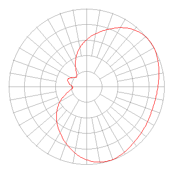 | ||||||||||||||||||||||||||||||
| Azimuth | Ratio | Azimuth | Ratio | Azimuth | Ratio | Azimuth | Ratio | ||||||||||||||||||||||||
| 0 | 0.599 | 10 | 0.688 | 20 | 0.778 | 30 | 0.873 | ||||||||||||||||||||||||
| 40 | 0.951 | 50 | 0.993 | 56 | 1.000 | 60 | 0.998 | ||||||||||||||||||||||||
| 70 | 0.976 | 80 | 0.944 | 90 | 0.918 | 100 | 0.901 | ||||||||||||||||||||||||
| 110 | 0.895 | 120 | 0.908 | 130 | 0.921 | 140 | 0.942 | ||||||||||||||||||||||||
| 150 | 0.974 | 160 | 0.995 | 170 | 0.985 | 180 | 0.940 | ||||||||||||||||||||||||
| 190 | 0.865 | 200 | 0.775 | 210 | 0.684 | 220 | 0.593 | ||||||||||||||||||||||||
| 230 | 0.497 | 240 | 0.392 | 250 | 0.280 | 260 | 0.197 | ||||||||||||||||||||||||
| 267 | 0.179 | 270 | 0.184 | 280 | 0.226 | 290 | 0.257 | ||||||||||||||||||||||||
| 300 | 0.227 | 310 | 0.183 | 314 | 0.178 | 320 | 0.194 | ||||||||||||||||||||||||
| 330 | 0.278 | 340 | 0.393 | 350 | 0.502 | ||||||||||||||||||||||||||
Structure Registration Number 1035880 Structure Type: Registered To: Oregon Public Broadcasting Structure Address: 62700 Awbrey Butte Bend, OR County Name: Deschutes County ASR Issued: 05/26/2020 Date Built: 07/21/2006 Site Elevation: 1286.3 m (4220 ft.) Structure Height: 71 m (233 ft.) Height Overall: 106.6 m (350 ft.) Overall Height AMSL: 1392.9 m (4570 ft.) FAA Determination: 07/20/2004 FAA Study #: 2004-ANM-365-OE FAA Circular #: 70/7460-1K Paint & Light FAA Chapters: 3, 4, 5, 12 PRIOR STUDY 2001-ANM-2364-OE 44-04-40.0 N 121-20-01.0 W (NAD 83) 44-04-40.6 N 121-19-56.9 W (Converted to NAD 27) |
525 Junction Road Madison, WI 53717 Phone: 608-664-4000 Limited Liability Company | Title: Vice President Date: 06/26/2015 Application Certifier TDS BROADCASTING LLC Tds Broadcasting Llc 525 Junction Road Attn: Mark E. Barber Madison, WI 53717 Applicant LOUIS R. DUTREIL, JR. Dutreil Lundin & Rackley Inc. 201 Fletcher Ave. Sarasota, FL 34237 CONSULTING ENGINEER WILLIAM LEBEAU, ESQ. Holland & Knight Llp 800 17th Street Nw, Suite 1100 Washington, DC 20006 | |||||||||||||||||||||||||||||