
FCCInfo.com
A Service of Cavell, Mertz & Associates, Inc.
(855) FCC-INFO
|
|
KHMP-LD from 04/01/2003 KHMP-LD from 03/12/2002 |
|
|
||||||||||||||||||||||||||||
|
|
Status: License Application Accepted: 05/02/2016 License Expires: 10/01/2022 File Number: -0000010687 FCC Website Links: LMS Facility Details This Application Other KHMP-LD Applications Including Superseded Applications Mailing Address Correspondence for KHMP-LD Correspondence related to application -0000010687 Service Contour - Open Street Map or USGS Map (51 dBu) Service Contour - KML / Google Earth (51 dBu) Rabbit Ears Info Search for KHMP-LD Site Location: 36-00-34.2 N 115-00-22.1 W (NAD 83) Site Location: 36-00-34.3 N 115-00-19.1 W (Converted to NAD 27) ERP: 15 kW Polarization: Horizontally polarized R/C AGL: 15.2 m (50 ft.) R/C AMSL: 1011.5 m (3319 ft.) Emission Mask: Full Service Site Elevation: 996.3 m. (3269 ft.) Height Overall*: 31.1 m (102 ft.) (* As Filed In This Application, may differ from ASR Data, Below.) Directional Antenna - Antenna Make/Model: Propagation System Inc PSILP12AP Antenna ID: 20356 Polarization: Horizontally polarized | ||||||||||||||||||||||||||||||
| Antenna Data for Antenna Id: 20356 KHMP-LD LD File: -0000010687 Propagation System Inc - PSILP12AP Service: LD Standard Pattern: Y Pattern and Field Values Include a 50° Clockwise Rotation | 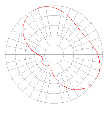 | ||||||||||||||||||||||||||||||
| Azimuth | Ratio | Azimuth | Ratio | Azimuth | Ratio | Azimuth | Ratio | ||||||||||||||||||||||||
| 0 | 0.954 | 10 | 0.898 | 20 | 0.835 | 30 | 0.777 | ||||||||||||||||||||||||
| 40 | 0.738 | 50 | 0.728 | 60 | 0.738 | 70 | 0.777 | ||||||||||||||||||||||||
| 80 | 0.835 | 90 | 0.898 | 100 | 0.954 | 110 | 0.992 | ||||||||||||||||||||||||
| 120 | 1.000 | 130 | 0.973 | 140 | 0.918 | 150 | 0.832 | ||||||||||||||||||||||||
| 160 | 0.716 | 170 | 0.584 | 180 | 0.446 | 190 | 0.326 | ||||||||||||||||||||||||
| 200 | 0.259 | 210 | 0.250 | 220 | 0.289 | 230 | 0.305 | ||||||||||||||||||||||||
| 240 | 0.289 | 250 | 0.250 | 260 | 0.259 | 270 | 0.326 | ||||||||||||||||||||||||
| 280 | 0.446 | 290 | 0.584 | 300 | 0.716 | 310 | 0.832 | ||||||||||||||||||||||||
| 320 | 0.918 | 330 | 0.973 | 340 | 1.000 | 350 | 0.992 | ||||||||||||||||||||||||
Structure Registration Number 1058295 Structure Type: LTOWER Registered To: American Towers LLC Structure Address: Black Mtn., Black Mountain Rd., .7 Mi. W Of I-515 (black Mtn T9 #90349--can) Henderson, NV County Name: Clark County ASR Issued: 05/22/2017 Date Built: 03/01/1999 Site Elevation: 996.3 m (3269 ft.) Structure Height: 24.4 m (80 ft.) Height Overall: 31.1 m (102 ft.) Overall Height AMSL: 1027.4 m (3371 ft.) FAA Determination: 12/18/2002 FAA Study #: 2002-AWP-3749-OE Paint & Light FAA Chapters: NONE PRIOR STUDY 2002-AWP-3748-OE 36-00-34.2 N 115-00-22.1 W (NAD 83) 36-00-34.3 N 115-00-19.1 W (Converted to NAD 27) |
1498 Buford Hwy Ste C 275 Sugar Hill, GA 30518 Phone: 770-771-1644 Applicant | Title: Member/manager Date: 05/02/2016 Application Certifier DNV SPECTRUM HOLDINGS, LLC Dnv Spectrum Holdings, Llc 5445 Peachtree Dunwoody Rd Atlanta, GA 30342 Applicant Byron W. St. Clair B. W. St. Clair 2355 Ranch Drive Westminster, CO 80234 Engineering Consultant | |||||||||||||||||||||||||||||
| |||||||||||||||||||||||||||||||