
FCCInfo.com
A Service of Cavell, Mertz & Associates, Inc.
(855) FCC-INFO
|
|
K33CP-D from 08/18/1988 |
|
|
||||||||||||||||
|
|
Status: License Application Accepted: 06/14/2016 License Expires: 02/01/2023 File Number: -0000011190 FCC Website Links: LMS Facility Details This Application Other K33CP-D Applications Including Superseded Applications Mailing Address Correspondence for K33CP-D Correspondence related to application -0000011190 Service Contour - Open Street Map or USGS Map (51 dBu) Service Contour - KML / Google Earth (51 dBu) Rabbit Ears Info Search for K33CP-D Site Location: 42-26-24.0 N 124-25-02.0 W (NAD 83) Site Location: 42-26-24.6 N 124-24-57.6 W (Converted to NAD 27) ERP: 0.5 kW Polarization: Horizontally polarized R/C AGL: 4 m (13 ft.) R/C AMSL: 211.3 m (693 ft.) Emission Mask: Simple Site Elevation: 207.3 m. (680 ft.) Height Overall*: 27.4 m (90 ft.) (* As Filed In This Application, may differ from ASR Data, Below.) Directional Antenna - Antenna Make/Model: Scala CL-1483 ARRAY Antenna ID: 119914 Polarization: Horizontally polarized | ||||||||||||||||||
| Antenna Data for Antenna Id: 119914 K33CP-D LD File: -0000011190 Scala - CL-1483 ARRAY Service: LD Standard Pattern: Y | 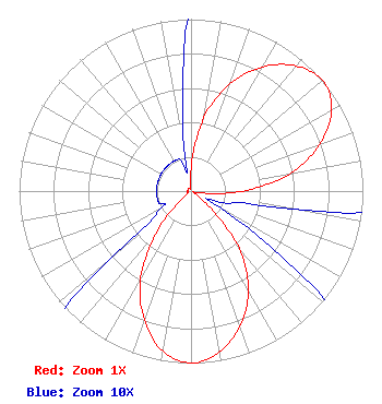 | ||||||||||||||||||
| Azimuth | Ratio | Azimuth | Ratio | Azimuth | Ratio | Azimuth | Ratio | ||||||||||||
| 0 | 0.130 | 10 | 0.435 | 20 | 0.665 | 30 | 0.834 | ||||||||||||
| 40 | 0.950 | 50 | 1.000 | 60 | 0.945 | 70 | 0.794 | ||||||||||||
| 80 | 0.585 | 90 | 0.300 | 100 | 0.060 | 110 | 0.020 | ||||||||||||
| 120 | 0.020 | 130 | 0.130 | 140 | 0.435 | 150 | 0.665 | ||||||||||||
| 160 | 0.834 | 170 | 0.950 | 180 | 1.000 | 190 | 0.945 | ||||||||||||
| 200 | 0.794 | 210 | 0.585 | 220 | 0.300 | 230 | 0.060 | ||||||||||||
| 240 | 0.020 | 250 | 0.020 | 260 | 0.020 | 270 | 0.020 | ||||||||||||
| 280 | 0.020 | 290 | 0.020 | 300 | 0.020 | 310 | 0.020 | ||||||||||||
| 320 | 0.020 | 330 | 0.020 | 340 | 0.020 | 350 | 0.020 | ||||||||||||
Structure Registration Number 1055653 Structure Type: TOWER Registered To: SMULLIN, PATRICIA C DBA = CALIFORNIA OREGON BROADCASTING INC Structure Address: 0.6 Miles North Of Wedderburn Gold Beach, OR County Name: Curry County ASR Issued: 08/26/1998 Date Built: 04/01/1985 Site Elevation: 207.3 m (680 ft.) Structure Height: 27.4 m (90 ft.) Height Overall: 27.4 m (90 ft.) Overall Height AMSL: 234.7 m (770 ft.) FAA Determination: 08/03/1998 FAA Study #: 98-ANM-0695-OE FAA Circular #: 70/7460-1J Paint & Light FAA Chapters: 4, 5, 13 Removed expiration date from determination. Scenario 1./jjs/case#635066 42-26-24.0 N 124-25-02.0 W (NAD 83) 42-26-24.6 N 124-24-57.6 W (Converted to NAD 27) |
C/o Miles S. Mason, Esq. - Pillsbury Winthrop 1200 Seventeenth Street, Nw Washington, DC 20036 Phone: 202-663-8195 Limited Liability Company | Title: Secretary, Sinclair Television Group, Inc. Date: 06/14/2016 Application Certifier SINCLAIR EUGENE LICENSEE, LLC Sinclair Eugene Licensee, Llc C/o C. Harrington - Pillsbury Winthrop S 1200 Seventeenth Street, Nw Washington, DC 20036 Applicant CLIFFORD M. HARRINGTON, ESQ Pillsbury Winthrop Shaw Pittman Llp 1200 Seventeenth Street, Nw Washington, DC 20036 Byron W. St. Clair B. W. St. Clair 2355 Ranch Drive Westminster, CO 80234 ENGINEERING CONSULTANT | |||||||||||||||||