
FCCInfo.com
A Service of Cavell, Mertz & Associates, Inc.
(855) FCC-INFO
|
|
K15KB-D from 01/26/2015 |
|
|
||||||||||||||||
|
|
Status: License Application Accepted: 06/14/2016 License Expires: 02/01/2023 File Number: -0000011191 FCC Website Links: LMS Facility Details This Application Other K15KB-D Applications Including Superseded Applications Mailing Address Correspondence for K15KB-D Correspondence related to application -0000011191 Service Contour - Open Street Map or USGS Map (51 dBu) Service Contour - KML / Google Earth (51 dBu) Rabbit Ears Info Search for K15KB-D Site Location: 42-23-50.0 N 124-21-54.4 W (NAD 83) Site Location: 42-23-50.6 N 124-21-50.0 W (Converted to NAD 27) ERP: 0.1 kW Polarization: Horizontally polarized Electrical Beam Tilt: 1.75 degrees R/C AGL: 12 m (39 ft.) R/C AMSL: 725.2 m (2379 ft.) Emission Mask: Stringent Site Elevation: 713.2 m. (2340 ft.) Height Overall*: 21.3 m (70 ft.) (* As Filed In This Application, may differ from ASR Data, Below.) Directional Antenna - Antenna Make/Model: Scala SL-8 Antenna ID: 23503 Polarization: Horizontally polarized | ||||||||||||||||||
| Antenna Data for Antenna Id: 23503 K15KB-D LD File: -0000011191 Scala - SL-8 Service: LD Standard Pattern: Y Pattern and Field Values Include a 270° Clockwise Rotation | 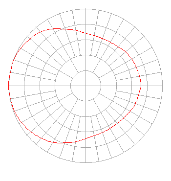 | ||||||||||||||||||
| Azimuth | Ratio | Azimuth | Ratio | Azimuth | Ratio | Azimuth | Ratio | ||||||||||||
| 0 | 0.680 | 10 | 0.660 | 20 | 0.650 | 30 | 0.650 | ||||||||||||
| 40 | 0.660 | 50 | 0.680 | 60 | 0.690 | 70 | 0.700 | ||||||||||||
| 80 | 0.710 | 90 | 0.720 | 100 | 0.700 | 110 | 0.690 | ||||||||||||
| 120 | 0.670 | 130 | 0.650 | 140 | 0.640 | 150 | 0.640 | ||||||||||||
| 160 | 0.650 | 170 | 0.660 | 180 | 0.690 | 190 | 0.740 | ||||||||||||
| 200 | 0.790 | 210 | 0.850 | 220 | 0.890 | 230 | 0.930 | ||||||||||||
| 240 | 0.960 | 250 | 0.980 | 260 | 0.990 | 270 | 1.000 | ||||||||||||
| 280 | 0.990 | 290 | 0.990 | 300 | 0.970 | 310 | 0.940 | ||||||||||||
| 320 | 0.910 | 330 | 0.850 | 340 | 0.780 | 350 | 0.730 | ||||||||||||
Structure Registration Number 1291886 Structure Type: LTOWER Registered To: Frontier Communications Northwest Inc. Structure Address: 3.1 Miles East Of Gold Beach Gold Beach, OR County Name: Curry County ASR Issued: 05/29/2014 Date Built: 02/16/1959 Site Elevation: 713.2 m (2340 ft.) Structure Height: 21.3 m (70 ft.) Height Overall: 21.3 m (70 ft.) Overall Height AMSL: 734.5 m (2410 ft.) FAA Determination: 11/19/2013 FAA Study #: 2013-ANM-2298-OE Paint & Light FAA Chapters: NONE PRIOR STUDY 2009-ANM-574-OE 42-23-50.0 N 124-21-54.4 W (NAD 83) 42-23-50.6 N 124-21-50.0 W (Converted to NAD 27) |
C/o Miles S. Mason, Esq. - Pillsbury Winthrop 1200 Seventeenth Street, Nw Washington, DC 20036 Phone: 202-663-8195 Limited Liability Company | Title: Secretary, Sinclair Television Group, Inc. Date: 06/14/2016 Application Certifier SINCLAIR EUGENE LICENSEE, LLC Sinclair Eugene Licensee, Llc C/o C. Harrington - Pillsbury Winthrop S 1200 Seventeenth Street, Nw Washington, DC 20036 Applicant CLIFFORD M. HARRINGTON, ESQ Pillsbury Winthrop Shaw Pittman Llp 1200 Seventeenth Street, Nw Washington, DC 20036 Byron W. St. Clair B. W. St. Clair 2355 Ranch Drive Westminster, CO 80234 ENGINEERING CONSULTANT | |||||||||||||||||