
FCCInfo.com
A Service of Cavell, Mertz & Associates, Inc.
(855) FCC-INFO
|
|
WUOA-LD from 06/29/2016 WUOA-LD from 04/23/2003 WUOA-LD from 09/10/1992 WUOA-LD from 08/21/1990 WUOA-LD from 01/27/1988 |
|
|
||||||||||||||||
|
|
Status: License Application Accepted: 06/27/2016 License Expires: 04/01/2021 File Number: -0000011374 FCC Website Links: LMS Facility Details This Application Other WUOA-LD Applications Including Superseded Applications Mailing Address Correspondence for WUOA-LD Correspondence related to application -0000011374 Service Contour - Open Street Map or USGS Map (51 dBu) Service Contour - KML / Google Earth (51 dBu) Rabbit Ears Info Search for WUOA-LD Site Location: 33-29-04.8 N 86-48-25.2 W (NAD 83) Site Location: 33-29-04.4 N 86-48-25.2 W (Converted to NAD 27) ERP: 10.46 kW Polarization: Horizontally polarized R/C AGL: 115.8 m (380 ft.) R/C AMSL: 404.4 m (1327 ft.) Emission Mask: Full Service Site Elevation: 288.6 m. (947 ft.) Height Overall*: 335.9 m (1102 ft.) (* As Filed In This Application, may differ from ASR Data, Below.) Directional Antenna - Antenna Make/Model: DIELECTRIC TUA-P2-0641 Antenna ID: 120743 Polarization: Horizontally polarized | ||||||||||||||||||
| Antenna Data for Antenna Id: 120743 WUOA-LD LD File: -0000011374 DIELECTRIC - TUA-P2-0641 Service: LD Standard Pattern: Y Pattern and Field Values Include a 20° Clockwise Rotation | 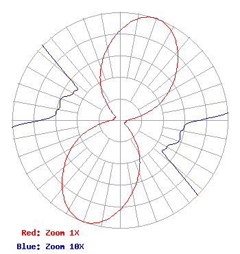 | ||||||||||||||||||
| Azimuth | Ratio | Azimuth | Ratio | Azimuth | Ratio | Azimuth | Ratio | ||||||||||||
| 0 | 0.829 | 10 | 0.952 | 20 | 1.000 | 30 | 0.952 | ||||||||||||
| 40 | 0.830 | 50 | 0.677 | 60 | 0.519 | 70 | 0.351 | ||||||||||||
| 80 | 0.173 | 90 | 0.074 | 100 | 0.058 | 110 | 0.058 | ||||||||||||
| 120 | 0.050 | 130 | 0.063 | 140 | 0.183 | 150 | 0.355 | ||||||||||||
| 160 | 0.515 | 170 | 0.674 | 180 | 0.829 | 190 | 0.952 | ||||||||||||
| 200 | 1.000 | 210 | 0.952 | 220 | 0.830 | 230 | 0.677 | ||||||||||||
| 240 | 0.519 | 250 | 0.351 | 260 | 0.173 | 270 | 0.074 | ||||||||||||
| 280 | 0.058 | 290 | 0.058 | 300 | 0.050 | 310 | 0.063 | ||||||||||||
| 320 | 0.183 | 330 | 0.355 | 340 | 0.515 | 350 | 0.674 | ||||||||||||
Structure Registration Number 1226663 Structure Type: GTOWER Registered To: American Towers LLC Structure Address: 2371 Golden Crest Drive (023660) Birmingham, AL County Name: Jefferson County ASR Issued: 05/31/2013 Date Built: 07/23/2002 Site Elevation: 288.6 m (947 ft.) Structure Height: 291.4 m (956 ft.) Height Overall: 335.9 m (1102 ft.) Overall Height AMSL: 624.5 m (2049 ft.) FAA Determination: 05/15/2013 FAA Study #: 2013-ASO-3274-OE FAA Circular #: 70/7460-1K Paint & Light FAA Chapters: 4, 9, 12 OM&L to remain the same as prior study = A HIGH-DUAL SYSTEM 33-29-04.8 N 86-48-25.2 W (NAD 83) 33-29-04.4 N 86-48-25.2 W (Converted to NAD 27)  American Tower Corporation 23660 - BIRMINGHAM AL5 |
295 Madison Avenue, 12th Floor New York, NY 10017 Phone: 954-606-5486 Corporation | Title: President Date: 06/27/2016 Application Certifier Dtv America Corporation 13450 W Sunrise Blvd Ste 164 Sunrise, FL 33323 Applicant RENEE ILHARDT Dtv America Corporation 13450 W Sunrise Blvd, Ste 164 Sunrise, FL 33323 | |||||||||||||||||