
FCCInfo.com
A Service of Cavell, Mertz & Associates, Inc.
(855) FCC-INFO
|
|
WYCN-LD from 10/06/2016 WYCN-LD from 02/14/2002 WYCN-LD from 05/12/1992 |
Virtual Channel 8 |
|
||||||||||||||||
|
|
Status: STA – Special Temporary Authority Application Accepted: 09/07/2016 STA Expires: 00/00/0000 File Number: -0000013941 FCC Website Links: LMS Facility Details This Application Other WYCN-LD Applications Including Superseded Applications Mailing Address Correspondence for WYCN-LD Correspondence related to application -0000013941 Service Contour - Open Street Map or USGS Map (74 dBu) Service Contour - KML / Google Earth (74 dBu) Rabbit Ears Info Search for WYCN-LD Site Location: 42-25-52.0 N 71-05-17.0 W (NAD 83) Site Location: 42-25-51.7 N 71-05-18.8 W (Converted to NAD 27) ERP: 2.35 kW Polarization: Horizontally polarized R/C AGL: 30.5 m (100 ft.) R/C AMSL: 87.8 m (288 ft.) Site Elevation: 57.3 m. (188 ft.) Height Overall*: 108.8 m (357 ft.) (* As Filed In This Application, may differ from ASR Data, Below.) Directional Antenna - Antenna Make/Model: Kathrein K723147 Antenna ID: 108653 Polarization: Horizontally polarized | ||||||||||||||||||
| Antenna Data for Antenna Id: 108653 WYCN-LD TX File: -0000013941 Kathrein - K723147 Service: TX Standard Pattern: Y Pattern and Field Values Include a 300° Clockwise Rotation | 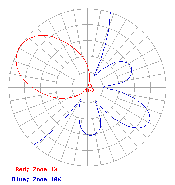 | ||||||||||||||||||
| Azimuth | Ratio | Azimuth | Ratio | Azimuth | Ratio | Azimuth | Ratio | ||||||||||||
| 0 | 0.270 | 10 | 0.160 | 20 | 0.080 | 30 | 0.020 | ||||||||||||
| 40 | 0.030 | 50 | 0.050 | 60 | 0.060 | 70 | 0.060 | ||||||||||||
| 80 | 0.050 | 90 | 0.020 | 100 | 0.050 | 110 | 0.080 | ||||||||||||
| 120 | 0.090 | 130 | 0.080 | 140 | 0.050 | 150 | 0.020 | ||||||||||||
| 160 | 0.050 | 170 | 0.060 | 180 | 0.060 | 190 | 0.050 | ||||||||||||
| 200 | 0.030 | 210 | 0.020 | 220 | 0.080 | 230 | 0.160 | ||||||||||||
| 240 | 0.270 | 250 | 0.400 | 260 | 0.540 | 270 | 0.700 | ||||||||||||
| 280 | 0.860 | 290 | 0.960 | 300 | 1.000 | 310 | 0.960 | ||||||||||||
| 320 | 0.860 | 330 | 0.700 | 340 | 0.540 | 350 | 0.400 | ||||||||||||
Structure Registration Number 1003922 Structure Type: LTOWER Registered To: Industrial Tower and Wireless, LLC Structure Address: 146 Murray St Medford, MA County Name: Middlesex County ASR Issued: 03/03/2023 Date Built: 01/01/1985 Site Elevation: 57.3 m (188 ft.) Structure Height: 105 m (344 ft.) Height Overall: 108.8 m (357 ft.) Overall Height AMSL: 166.1 m (545 ft.) FAA Determination: 02/27/2023 FAA Study #: 2022-ANE-2141-OE FAA Circular #: 70/7460-1K Paint & Light FAA Chapters: 4, 8, 12 OM&L to remain the same as prior study = A MED-DUAL SYSTEM 42-25-52.0 N 71-05-17.0 W (NAD 83) 42-25-51.7 N 71-05-18.8 W (Converted to NAD 27) |
300 New Jersey Avenue, Nw Suite 700 Washington, DC 20001 Phone: 202-524-6413 Limited Partnership | Title: Vice President Date: 09/07/2016 Application Certifier ZGS BOSTON, INC. Zgs Boston, Inc. 2000 North 14th Street Suite 400 Arlington, VA 22201 Applicant P.E Dane E. Ericksen E. Ericksen, P.E Hammet & Edison, Inc. 470 Third Street West Sonoma, CA 95476 Esq David M. Silverman M. Silverman, Esq Davis Wright Tremaine Llp 1919 Pennsylvania Ave., Nw Suite 800 Washington, DC 20006 | |||||||||||||||||
| |||||||||||||||||||