
FCCInfo.com
A Service of Cavell, Mertz & Associates, Inc.
(855) FCC-INFO
|
|
K15GT-D from 11/09/2016 K15GT-D from 09/10/2004 K15GT-D from 09/26/2003 |
|
|
||||||||||||||||
|
|
Status: License Application Accepted: 10/27/2016 License Expires: 04/01/2022 File Number: -0000016503 FCC Website Links: LMS Facility Details This Application Other K15GT-D Applications Including Superseded Applications Mailing Address Correspondence for K15GT-D Correspondence related to application -0000016503 Service Contour - Open Street Map or USGS Map (51 dBu) Service Contour - KML / Google Earth (51 dBu) Rabbit Ears Info Search for K15GT-D Site Location: 47-22-51.3 N 92-57-19.6 W (NAD 83) Site Location: 47-22-51.5 N 92-57-18.9 W (Converted to NAD 27) ERP: 8.04 kW Polarization: Horizontally polarized Electrical Beam Tilt: 1.25 degrees R/C AGL: 53.3 m (175 ft.) R/C AMSL: 554.7 m (1820 ft.) Emission Mask: Simple Site Elevation: 501.4 m. (1645 ft.) Height Overall*: 82 m (269 ft.) (* As Filed In This Application, may differ from ASR Data, Below.) Directional Antenna - Antenna Make/Model: Electronics Research Inc. AL12 Antenna ID: 66203 Polarization: Horizontally polarized
| ||||||||||||||||||
| Antenna Data for Antenna Id: 66203 K15GT-D LD File: -0000016503 Electronics Research Inc. - AL12 Service: LD Standard Pattern: Y | 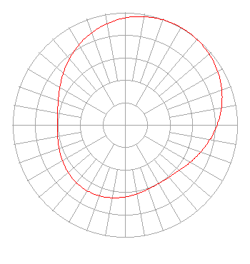 | ||||||||||||||||||
| Azimuth | Ratio | Azimuth | Ratio | Azimuth | Ratio | Azimuth | Ratio | ||||||||||||
| 0 | 0.951 | 10 | 0.978 | 20 | 0.994 | 30 | 1.000 | ||||||||||||
| 40 | 0.994 | 50 | 0.978 | 60 | 0.951 | 70 | 0.915 | ||||||||||||
| 80 | 0.871 | 90 | 0.820 | 100 | 0.767 | 110 | 0.715 | ||||||||||||
| 120 | 0.668 | 130 | 0.631 | 140 | 0.609 | 150 | 0.602 | ||||||||||||
| 160 | 0.608 | 170 | 0.623 | 180 | 0.642 | 190 | 0.659 | ||||||||||||
| 200 | 0.672 | 210 | 0.676 | 220 | 0.672 | 230 | 0.659 | ||||||||||||
| 240 | 0.642 | 250 | 0.623 | 260 | 0.608 | 270 | 0.602 | ||||||||||||
| 280 | 0.609 | 290 | 0.631 | 300 | 0.668 | 310 | 0.715 | ||||||||||||
| 320 | 0.767 | 330 | 0.820 | 340 | 0.871 | 350 | 0.915 | ||||||||||||
Structure Registration Number 1027748 [ASR Heights Differ from K15GT-D Application] Structure Type: LTOWER Registered To: SBA Structures, LLC Structure Address: 3621 Tower Rd. (mn20762-a) Hibbing, MN County Name: St. Louis County ASR Issued: 08/25/2023 Date Built: 02/25/2000 Site Elevation: 502.9 m (1650 ft.) Structure Height: 76.5 m (251 ft.) Height Overall: 82 m (269 ft.) Overall Height AMSL: 584.9 m (1919 ft.) FAA Determination: 02/08/2023 FAA Study #: 2022-AGL-21621-OE FAA Circular #: 70/7460-1J Paint & Light FAA Chapters: 4, 8, 13 OM&L to remain the same as prior study = A MED-DUAL SYSTEM 47-22-51.3 N 92-57-19.7 W (NAD 83) 47-22-51.5 N 92-57-19.0 W (Converted to NAD 27) |
2750 Luberon Lane Cumming, GA 30041 Phone: 678-777-8659 Limited Liability Company | Title: Chief Operating Officer Date: 10/27/2016 Application Certifier KQDS ACQUISITION CORP. Kqds Acquisition Corp. P. O. Box 9115 Fargo, ND 58106 Applicant CHARLES R. NAFTALIN, ESQ. Holland & Knight Llp 800 17th Street N.w., Suite 1100 Washington, DC 20006 FCC LEGAL COUNSEL | |||||||||||||||||