
FCCInfo.com
A Service of Cavell, Mertz & Associates, Inc.
(855) FCC-INFO
|
|
KUMO-LD from 04/02/2004 KUMO-LD from 12/23/1997 KUMO-LD from 01/21/1986 |
|
|
||||||||||||||||
|
|
Status: Construction Permit Application Accepted: 10/02/2017 KUMO-LD CP Expires: 07/27/2021 File Number: -0000030456 FCC Website Links: LMS Facility Details This Application Other KUMO-LD Applications Including Superseded Applications Mailing Address Correspondence for KUMO-LD Correspondence related to application -0000030456 Service Contour - Open Street Map or USGS Map (51 dBu) Service Contour - KML / Google Earth (51 dBu) Rabbit Ears Info Search for KUMO-LD Site Location: 38-34-27.9 N 90-19-31.9 W (NAD 83) Site Location: 38-34-27.7 N 90-19-31.5 W (Converted to NAD 27) ERP: 15 kW Polarization: Elliptically polarized Electrical Beam Tilt: 1 degree R/C AGL: 274.3 m (900 ft.) R/C AMSL: 411.5 m (1350 ft.) Emission Mask: Full Service Site Elevation: 137.2 m. (450 ft.) Height Overall*: 339.9 m (1115 ft.) (* As Filed In This Application, may differ from ASR Data, Below.) Directional Antenna - Antenna Make/Model: Systems With Reliability Inc. SWLP16PN Antenna ID: 24173 Polarization: Elliptically polarized | ||||||||||||||||||
| Antenna Data for Antenna Id: 24173 KUMO-LD LD File: -0000030456 Systems With Reliability Inc. - SWLP16PN Service: LD Standard Pattern: Y Pattern and Field Values Include a 120° Clockwise Rotation | 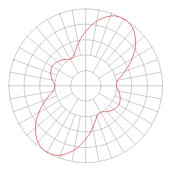 | ||||||||||||||||||
| Azimuth | Ratio | Azimuth | Ratio | Azimuth | Ratio | Azimuth | Ratio | ||||||||||||
| 0 | 0.700 | 10 | 0.850 | 20 | 0.960 | 30 | 1.000 | ||||||||||||
| 40 | 0.960 | 50 | 0.850 | 60 | 0.700 | 70 | 0.550 | ||||||||||||
| 80 | 0.430 | 90 | 0.400 | 100 | 0.440 | 110 | 0.480 | ||||||||||||
| 120 | 0.500 | 130 | 0.480 | 140 | 0.440 | 150 | 0.400 | ||||||||||||
| 160 | 0.430 | 170 | 0.550 | 180 | 0.700 | 190 | 0.850 | ||||||||||||
| 200 | 0.960 | 210 | 1.000 | 220 | 0.960 | 230 | 0.850 | ||||||||||||
| 240 | 0.700 | 250 | 0.550 | 260 | 0.430 | 270 | 0.400 | ||||||||||||
| 280 | 0.440 | 290 | 0.480 | 300 | 0.500 | 310 | 0.480 | ||||||||||||
| 320 | 0.440 | 330 | 0.400 | 340 | 0.430 | 350 | 0.550 | ||||||||||||
Structure Registration Number 1020785 Structure Type: GTOWER Registered To: American Towers, LLC Structure Address: 7555 Mackenzie Road (st. Louis Mo 4 #305889) Saint Louis, MO County Name: St. Louis County ASR Issued: 02/07/2020 Date Built: 05/01/1986 Site Elevation: 137.2 m (450 ft.) Structure Height: 339.9 m (1115 ft.) Height Overall: 339.9 m (1115 ft.) Overall Height AMSL: 477.1 m (1565 ft.) FAA Determination: 08/01/2013 FAA Study #: 2013-ACE-830-OE FAA Circular #: 70/7460-1K Paint & Light FAA Chapters: 3, 4, 5, 12 OM&L to remain the same as prior study = PAINT/RED LIGHTS 38-34-27.9 N 90-19-31.9 W (NAD 83) 38-34-27.7 N 90-19-31.5 W (Converted to NAD 27) |
3901 Highway 121 S Bedford, TX 76021 Phone: 817-571-1229 Not-for-Profit | Title: President Date: 10/02/2017 Application Certifier WPXS, INC. Wpxs, Inc. 3901 Highway 121 South Bedford, TX 73021 Applicant RICHARD C GOETZ Rl Media Systems Inc 135 N Country Club Dr Hendersonville, TN 37075 BROADCAST CONSULTANT ROBERT L OLENDER, ESQ Koerner & Olender P.c. 7020 Richard Drive Bethesda, MD 20817 ATTORNEY | |||||||||||||||||