
FCCInfo.com
A Service of Cavell, Mertz & Associates, Inc.
(855) FCC-INFO
|
|
DWCGV-TV from 04/09/1980 |
RF spectrum relinquished in the spectrum auction Virtual Channel 24 |  |
|
|||||||||||||||
|
|
Repacking Information: Channel 25 was relinquished in the spectrum auction Status: License Application Accepted: 01/10/2018 License Expires: 12/01/2005 File Number: -0000039354 FCC Website Links: LMS Facility Details This Application Other DWCGV-TV Applications Including Superseded Applications Mailing Address Correspondence for DWCGV-TV Correspondence related to application -0000039354 Service Contour - Open Street Map or USGS Map (41 dBu) Service Contour - KML / Google Earth (41 dBu) Public Inspection Files History Cards for DWCGV-TV Rabbit Ears Info Search for DWCGV-TV Site Location: 43-05-46.2 N 87-54-15.0 W (NAD 83) Site Location: 43-05-46.2 N 87-54-14.7 W (Converted to NAD 27) ERP: 1000 kW Polarization: Horizontally polarized HAAT: 340.3 m (1116 ft.) Electrical Beam Tilt: 0.75 degrees R/C AGL: 346 m (1135 ft.) R/C AMSL: 537.4 m (1763 ft.) Site Elevation: 191.4 m. (628 ft.) Height Overall*: 369.7 m (1213 ft.) (* As Filed In This Application, may differ from ASR Data, Below.) Directional Antenna - Antenna Make/Model: DIELECTRIC TFU-28DSC-R CT170 DC Antenna ID: 105589 Polarization: Horizontally polarized | ||||||||||||||||||
| Antenna Data for Antenna Id: 105589 DWCGV-TV DT File: -0000039354 DIELECTRIC - TFU-28DSC-R CT170 DC Service: DT Standard Pattern: Y | 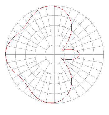 | ||||||||||||||||||
| Azimuth | Ratio | Azimuth | Ratio | Azimuth | Ratio | Azimuth | Ratio | ||||||||||||
| 0 | 0.984 | 10 | 0.934 | 20 | 0.837 | 30 | 0.691 | ||||||||||||
| 40 | 0.499 | 50 | 0.288 | 59 | 0.180 | 60 | 0.180 | ||||||||||||
| 70 | 0.310 | 80 | 0.450 | 90 | 0.503 | 100 | 0.450 | ||||||||||||
| 110 | 0.310 | 120 | 0.180 | 121 | 0.180 | 130 | 0.288 | ||||||||||||
| 140 | 0.499 | 150 | 0.691 | 160 | 0.837 | 170 | 0.934 | ||||||||||||
| 180 | 0.984 | 190 | 0.993 | 200 | 0.965 | 210 | 0.911 | ||||||||||||
| 220 | 0.854 | 230 | 0.830 | 240 | 0.857 | 250 | 0.919 | ||||||||||||
| 260 | 0.977 | 269 | 1.000 | 270 | 1.000 | 271 | 1.000 | ||||||||||||
| 280 | 0.977 | 290 | 0.919 | 300 | 0.857 | 310 | 0.830 | ||||||||||||
| 320 | 0.854 | 330 | 0.911 | 340 | 0.965 | 350 | 0.993 | ||||||||||||
Structure Registration Number 1057482 Structure Type: GTOWER Registered To: Milwaukee Area Technical College District Board Structure Address: 4350a N Humboldt Ave/atc Site-milwaukee/#075054 Milwaukee-53212, WI County Name: Milwaukee County ASR Issued: 08/26/2022 Date Built: 05/27/2015 Site Elevation: 191.4 m (628 ft.) Structure Height: 334.9 m (1099 ft.) Height Overall: 369.7 m (1213 ft.) Overall Height AMSL: 561.1 m (1841 ft.) FAA Determination: 07/03/2014 FAA Study #: 2014-AGL-6435-OE FAA Circular #: 70/7460-1K Paint & Light FAA Chapters: 4, 9, 12 PRIOR STUDY 2013-AGL-9774-OE 43-05-46.2 N 87-54-15.0 W (NAD 83) 43-05-46.2 N 87-54-14.7 W (Converted to NAD 27) |
C/o Miles S. Mason, Esq., Pillsbury Winthrop Shaw Pittman Llp 1200 Seventeenth Street, Nw Washington, DC 20036 Phone: 202-663-8195 Limited Liability Company | Title: Secretary Sinclair Television Group Inc Date: 01/10/2018 Application Certifier WCGV LICENSEE, LLC Wcgv Licensee, Llc 10706 Beaver Dam Road Cockeysville, MD 21030 Applicant Paul A. Cicelski, Esq Lerman Senter Pllc 2001 L St Nw Suite 400 Washington, DC 20036 | |||||||||||||||||