
FCCInfo.com
A Service of Cavell, Mertz & Associates, Inc.
(855) FCC-INFO
|
|
WILM-LD from 01/12/2007 |
|
|
|||||||||||||||||||
|
|
Status: License Application Accepted: 06/14/2018 License Expires: 12/01/2020 File Number: -0000055240 FCC Website Links: LMS Facility Details This Application Other WILM-LD Applications Including Superseded Applications Mailing Address Correspondence for WILM-LD Correspondence related to application -0000055240 Service Contour - Open Street Map or USGS Map (51 dBu) Service Contour - KML / Google Earth (51 dBu) Rabbit Ears Info Search for WILM-LD Site Location: 34-19-16.6 N 78-13-42.0 W (NAD 83) Site Location: 34-19-16.0 N 78-13-43.0 W (Converted to NAD 27) ERP: 15 kW Polarization: Horizontally polarized Electrical Beam Tilt: 1.75 degrees R/C AGL: 258.5 m (848 ft.) R/C AMSL: 264.3 m (867 ft.) Emission Mask: Full Service Site Elevation: 5.8 m. (19 ft.) Height Overall*: 310.9 m (1020 ft.) (* As Filed In This Application, may differ from ASR Data, Below.) Directional Antenna - Antenna Make/Model: Electronics Research Inc. AL8W-15 Antenna ID: 1003868 Polarization: Horizontally polarized
| |||||||||||||||||||||
| Antenna Data for Antenna Id: 1003868 WILM-LD LD File: -0000055240 Electronics Research Inc. - AL8W-15 Service: LD Standard Pattern: N | 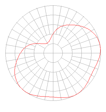 | |||||||||||||||||||||
| Azimuth | Ratio | Azimuth | Ratio | Azimuth | Ratio | Azimuth | Ratio | |||||||||||||||
| 0 | 0.397 | 10 | 0.510 | 20 | 0.605 | 30 | 0.680 | |||||||||||||||
| 40 | 0.758 | 50 | 0.845 | 60 | 0.922 | 70 | 0.975 | |||||||||||||||
| 80 | 0.997 | 90 | 0.990 | 100 | 0.959 | 110 | 0.929 | |||||||||||||||
| 120 | 0.925 | 130 | 0.951 | 140 | 0.985 | 150 | 1.000 | |||||||||||||||
| 160 | 0.985 | 170 | 0.951 | 180 | 0.925 | 190 | 0.929 | |||||||||||||||
| 200 | 0.959 | 210 | 0.990 | 220 | 0.997 | 230 | 0.975 | |||||||||||||||
| 240 | 0.922 | 250 | 0.845 | 260 | 0.758 | 270 | 0.680 | |||||||||||||||
| 280 | 0.605 | 290 | 0.510 | 300 | 0.397 | 310 | 0.302 | |||||||||||||||
| 320 | 0.253 | 330 | 0.241 | 340 | 0.253 | 350 | 0.302 | |||||||||||||||
Structure Registration Number 1014589 [ASR Heights Differ from WILM-LD Application] Structure Type: GTOWER Registered To: UNIVERSITY OF NORTH CAROLINA Structure Address: 521 Tv Tower Road Delco, NC County Name: Columbus County ASR Issued: 11/29/2023 Date Built: 02/10/2024 Site Elevation: 5.8 m (19 ft.) Structure Height: 292.2 m (959 ft.) Height Overall: 311.9 m (1023 ft.) Overall Height AMSL: 317.7 m (1042 ft.) FAA Determination: 04/25/2023 FAA Study #: 2022-ASO-42342-OE FAA Circular #: 70/7460-1M Paint & Light FAA Chapters: 4, 9, 15 PRIOR STUDY 2018-ASO-2421-OE 34-19-17.2 N 78-13-41.4 W (NAD 83) 34-19-16.6 N 78-13-42.4 W (Converted to NAD 27) |
2619 Western Blvd. Raleigh, NC 27606 Phone: 919-821-8933 Corporation | Title: Vice President Date: 06/14/2018 Application Certifier WILM, INC. Wilm, Inc. 25 N. Kerr Ave Wilmington, NC 28405 Applicant PETER SOCKETT Capitol Broadcasting Company, Inc. 2619 Western Boulevard Raleigh, NC 27606 TV DIRECTOR OF ENGINEERING AND OPERATIONS David A. O'Connor Wilkinson Barker Knauer, Llp 1800 M Street Nw Suite 800n Washington, DC 20036 Partner Louis R. duTreil, Jr Dutreil Lundin & Rackley Inc 3135 Southgate Circle Sarasota, FL 34239 Technical Consultant | ||||||||||||||||||||
| ||||||||||||||||||||||