
FCCInfo.com
A Service of Cavell, Mertz & Associates, Inc.
(855) FCC-INFO
|
|
WFND-LD from 01/20/1997 WFND-LD from 01/24/1990 |
|
|
||||||||||||||||
|
|
Status: License (Licensed And Silent) Application Accepted: 06/13/2018 License Expires: 10/01/2021 File Number: -0000055157 FCC Website Links: LMS Facility Details This Application Other WFND-LD Applications Including Superseded Applications Mailing Address Correspondence for WFND-LD Correspondence related to application -0000055157 Service Contour - Open Street Map or USGS Map (51 dBu) Service Contour - KML / Google Earth (51 dBu) Rabbit Ears Info Search for WFND-LD Site Location: 41-06-41.1 N 83-38-52.7 W (NAD 83) Site Location: 41-06-40.9 N 83-38-52.9 W (Converted to NAD 27) ERP: 15 kW Polarization: Elliptically polarized Electrical Beam Tilt: 1.0 degree R/C AGL: 86 m (282 ft.) R/C AMSL: 331.1 m (1086 ft.) Emission Mask: Simple Site Elevation: 245.1 m. (804 ft.) Height Overall*: 93.6 m (307 ft.) (* As Filed In This Application, may differ from ASR Data, Below.) Directional Antenna - Antenna Make/Model: Alive ATC-BCE48C1R-U Antenna ID: 1003859 Polarization: Elliptically polarized | ||||||||||||||||||
| Antenna Data for Antenna Id: 1003859 WFND-LD LD File: -0000055157 Alive - ATC-BCE48C1R-U Service: LD Standard Pattern: N | 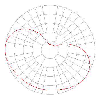 | ||||||||||||||||||
| Azimuth | Ratio | Azimuth | Ratio | Azimuth | Ratio | Azimuth | Ratio | ||||||||||||
| 0 | 0.118 | 10 | 0.115 | 20 | 0.110 | 30 | 0.115 | ||||||||||||
| 40 | 0.118 | 50 | 0.124 | 60 | 0.189 | 70 | 0.365 | ||||||||||||
| 80 | 0.550 | 90 | 0.725 | 100 | 0.854 | 110 | 0.940 | ||||||||||||
| 120 | 0.987 | 130 | 1.000 | 140 | 0.988 | 150 | 0.963 | ||||||||||||
| 160 | 0.936 | 170 | 0.917 | 180 | 0.905 | 190 | 0.900 | ||||||||||||
| 200 | 0.899 | 210 | 0.900 | 220 | 0.905 | 230 | 0.917 | ||||||||||||
| 240 | 0.936 | 250 | 0.963 | 260 | 0.988 | 270 | 1.000 | ||||||||||||
| 280 | 0.987 | 290 | 0.940 | 300 | 0.854 | 310 | 0.725 | ||||||||||||
| 320 | 0.550 | 330 | 0.365 | 340 | 0.189 | 350 | 0.124 | ||||||||||||
Structure Registration Number 1047246 Structure Type: GTOWER Registered To: SBA Structures, LLC Structure Address: 3800 North County Road 220 (oh20039-a) Findley, OH County Name: Hancock County ASR Issued: 01/29/2016 Date Built: 04/01/1993 Site Elevation: 245.1 m (804 ft.) Structure Height: 91.4 m (300 ft.) Height Overall: 93.6 m (307 ft.) Overall Height AMSL: 338.7 m (1111 ft.) FAA Determination: 09/24/2015 FAA Study #: 2015-AGL-13130-OE FAA Circular #: 70/7460-1H Paint & Light FAA Chapters: 3, 4, 5, 13 OM&L to remain the same as prior study = PAINT/RED LIGHTS 41-06-41.1 N 83-38-52.7 W (NAD 83) 41-06-40.9 N 83-38-52.9 W (Converted to NAD 27) |
1424 Rice Avenue Lima, OH 45805 Phone: 419-228-8835 Corporation | Title: President And General Manager Date: 06/13/2018 Application Certifier West Central Ohio Broadcasting, Inc. 1424 Rice Avenue Lima, OH 45805 Applicant Christina H. Burrow Cooley Llp 1299 Pennsylvania Ave., Nw Suite 700 Washington, DC 20004 Legal Counsel Donald G. Everist Cohen, Dippell And Everist, P.c. 1420 N Street, N.w. Suite One Washington, DC 20005 Technical Representative FRED VOBBE West Central Ohio Broadcasting, Inc. 1424 Rice Avenue Lima, OH 45805 CHIEF ENGINEER | |||||||||||||||||