
FCCInfo.com
A Service of Cavell, Mertz & Associates, Inc.
(855) FCC-INFO
|
|
|
Post-repack Channel 27 Virtual Channel 11 |  |
|
||||||||||||||||||
|
|
Repacking Information: Pre-Repack Channel: 47 Post-Repack Channel: 27 Post-Repack ERP: 142 kW Phase: 0 Completion Deadline: 8/1/2018 Find nearby TV Facilities Status: License Application Accepted: 08/07/2018 License Expires: 08/01/2021 File Number: -0000058637 FCC Website Links: LMS Facility Details This Application Other WLJT-DT Applications Including Superseded Applications Mailing Address Correspondence for WLJT-DT Correspondence related to application -0000058637 Service Contour - Open Street Map or USGS Map (41 dBu) Service Contour - KML / Google Earth (41 dBu) Public Inspection Files History Cards for WLJT-DT Rabbit Ears Info Search for WLJT-DT Site Location: 35-42-12.0 N 88-36-10.0 W (NAD 83) Site Location: 35-42-11.8 N 88-36-09.8 W (Converted to NAD 27) ERP: 142 kW Polarization: Horizontally polarized HAAT: 205 m (673 ft.) Electrical Beam Tilt: 0.5 degrees R/C AGL: 143.3 m (470 ft.) R/C AMSL: 346.9 m (1138 ft.) Site Elevation: 203.6 m. (668 ft.) Height Overall*: 152.1 m (499 ft.) (* As Filed In This Application, may differ from ASR Data, Below.) Directional Antenna - Antenna Make/Model: Jampro JA/MS-24/27-TEO Antenna ID: 1004001 Polarization: Horizontally polarized | |||||||||||||||||||||
| Antenna Data for Antenna Id: 1004001 WLJT-DT DT File: -0000058637 Jampro - JA/MS-24/27-TEO Service: DT Standard Pattern: N Pattern and Field Values Include a 315° Clockwise Rotation | 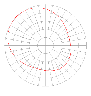 | |||||||||||||||||||||
| Azimuth | Ratio | Azimuth | Ratio | Azimuth | Ratio | Azimuth | Ratio | |||||||||||||||
| 5 | 0.871 | 15 | 0.820 | 25 | 0.767 | 35 | 0.715 | |||||||||||||||
| 45 | 0.668 | 55 | 0.631 | 65 | 0.609 | 75 | 0.602 | |||||||||||||||
| 85 | 0.608 | 95 | 0.623 | 105 | 0.642 | 115 | 0.659 | |||||||||||||||
| 125 | 0.672 | 135 | 0.676 | 145 | 0.672 | 155 | 0.659 | |||||||||||||||
| 165 | 0.642 | 175 | 0.623 | 185 | 0.608 | 195 | 0.602 | |||||||||||||||
| 205 | 0.609 | 215 | 0.631 | 225 | 0.668 | 235 | 0.715 | |||||||||||||||
| 245 | 0.767 | 255 | 0.820 | 265 | 0.871 | 275 | 0.915 | |||||||||||||||
| 285 | 0.951 | 295 | 0.978 | 305 | 0.994 | 315 | 1.000 | |||||||||||||||
| 325 | 0.994 | 335 | 0.978 | 345 | 0.951 | 355 | 0.915 | |||||||||||||||
Structure Registration Number 1043194 Structure Type: GTOWER Registered To: WEST TENNESSEE PUBLIC TV COUNCIL INC Structure Address: 12.5 Mi Nw Lexington, TN County Name: Henderson County ASR Issued: 03/04/2019 Date Built: 01/01/1966 Site Elevation: 203.6 m (668 ft.) Structure Height: 131.9 m (433 ft.) Height Overall: 152.1 m (499 ft.) Overall Height AMSL: 355.7 m (1167 ft.) FAA Determination: 03/01/2019 FAA Study #: 2018-ASO-26882-OE FAA Circular #: 70/7460-1L Paint & Light FAA Chapters: 3, 4, 5, 12 Removed expiration date from determination. Scenario 1./jjs/case#635066 35-42-12.0 N 88-36-10.4 W (NAD 83) 35-42-11.8 N 88-36-10.2 W (Converted to NAD 27) |
P.o. Box 966 Martin, TN 38237 Phone: 731-881-7561 Not-for-Profit | Title: General Manager And Ceo Date: 08/07/2018 Application Certifier West Tennessee Public Tv Council, Inc P.o. Box 966 Martin, TN 38237 Applicant Roy P Stype, III Carl E. Smith Consulting Engineers 2324 North Cleveland-massillon Road Bath, OH 44210 Consulting Engineer Lawrence M. Miller Garvey Schubert Barer 1000 Potomac Street, Nw Suite 200 Washington, DC 20007 Attorney | ||||||||||||||||||||
| ||||||||||||||||||||||