
FCCInfo.com
A Service of Cavell, Mertz & Associates, Inc.
(855) FCC-INFO
|
|
K29LQ-D from 09/21/2018 K29LQ-D from 07/25/2011 K29LQ-D from 03/24/2005 |
|
|
||||||||||||||||
|
|
Status: License Application Accepted: 09/20/2018 License Expires: 04/01/2022 File Number: -0000059725 FCC Website Links: LMS Facility Details This Application Other K29LQ-D Applications Including Superseded Applications Mailing Address Correspondence for K29LQ-D Correspondence related to application -0000059725 Service Contour - Open Street Map or USGS Map (51 dBu) Service Contour - KML / Google Earth (51 dBu) Rabbit Ears Info Search for K29LQ-D Site Location: 47-40-38.8 N 114-08-33.2 W (NAD 83) Site Location: 47-40-39.0 N 114-08-29.8 W (Converted to NAD 27) ERP: 0.061 kW Polarization: Horizontally polarized R/C AGL: 9 m (30 ft.) R/C AMSL: 1044.4 m (3427 ft.) Emission Mask: Full Service Site Elevation: 1035.4 m. (3397 ft.) Height Overall*: 9.1 m (30 ft.) (* As Filed In This Application, may differ from ASR Data, Below.) Directional Antenna - Antenna Make/Model: Scala CL-1469 Antenna ID: 20778 Polarization: Horizontally polarized
| ||||||||||||||||||
| Antenna Data for Antenna Id: 20778 K29LQ-D LD File: -0000059725 Scala - CL-1469 Service: LD Standard Pattern: Y Pattern and Field Values Include a 355° Clockwise Rotation | 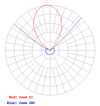 | ||||||||||||||||||
| Azimuth | Ratio | Azimuth | Ratio | Azimuth | Ratio | Azimuth | Ratio | ||||||||||||
| 5 | 0.947 | 15 | 0.812 | 25 | 0.622 | 35 | 0.361 | ||||||||||||
| 45 | 0.086 | 55 | 0.010 | 65 | 0.010 | 75 | 0.010 | ||||||||||||
| 85 | 0.010 | 95 | 0.010 | 105 | 0.010 | 115 | 0.010 | ||||||||||||
| 125 | 0.010 | 135 | 0.010 | 145 | 0.010 | 155 | 0.010 | ||||||||||||
| 165 | 0.010 | 175 | 0.010 | 185 | 0.010 | 195 | 0.010 | ||||||||||||
| 205 | 0.010 | 215 | 0.010 | 225 | 0.010 | 235 | 0.010 | ||||||||||||
| 245 | 0.010 | 255 | 0.010 | 265 | 0.010 | 275 | 0.010 | ||||||||||||
| 285 | 0.010 | 295 | 0.010 | 305 | 0.086 | 315 | 0.361 | ||||||||||||
| 325 | 0.622 | 335 | 0.812 | 345 | 0.947 | 355 | 1.000 | ||||||||||||
Structure Registration Number 1242285 Structure Type: TOWER Registered To: BlackTail TV Tax District Structure Address: Radio Hill (polson, Mt.) Polson, MT County Name: Lake County ASR Issued: 02/27/2004 Date Built: 01/01/1984 Site Elevation: 1035.4 m (3397 ft.) Structure Height: 9.1 m (30 ft.) Height Overall: 9.1 m (30 ft.) Overall Height AMSL: 1044.5 m (3427 ft.) FAA Determination: 02/24/2004 FAA Study #: 2004-ANM-139-OE Paint & Light FAA Chapters: NONE 47-40-38.8 N 114-08-33.2 W (NAD 83) 47-40-39.0 N 114-08-29.8 W (Converted to NAD 27) |
106 4th Ave E Polson, MT 59860 Phone: 406-249-3251 Government Entity | Title: Board Member Date: 09/20/2018 Application Certifier BLACKTAIL TV TAX DISTRICT Blacktail Tv Tax District 106 4th Ave E Polson, MT 59860 Applicant JOHN R BARNETT Bps, Llc 13806 E, 22nd Lane Spokane, WA 99216 CONSULTING ENGINEER Steven Fite Blacktail Tv Tax District 115 6th Ave W Polson, MT 59860 | |||||||||||||||||