
FCCInfo.com
A Service of Cavell, Mertz & Associates, Inc.
(855) FCC-INFO
|
|
|
|
|
||||||||||||||||
|
|
Status: STA – Special Temporary Authority Application Accepted: 03/04/2019 STA Expires: 00/00/0000 File Number: -0000068254 FCC Website Links: LMS Facility Details This Application Other W20DS-D Applications Including Superseded Applications Mailing Address Correspondence for W20DS-D Correspondence related to application -0000068254 Service Contour - Open Street Map or USGS Map (51 dBu) Service Contour - KML / Google Earth (51 dBu) Rabbit Ears Info Search for W20DS-D Site Location: 17-59-28.0 N 66-06-23.7 W (NAD 83) Site Location: 17-59-35.1 N 66-06-25.1 W (Converted to NAD 27) ERP: 1 kW Polarization: Horizontally polarized Electrical Beam Tilt: 0.25 degrees R/C AGL: 20 m (66 ft.) R/C AMSL: 256.5 m (842 ft.) Emission Mask: Full Service Site Elevation: 236.5 m. (776 ft.) Height Overall*: 60.7 m (199 ft.) (* As Filed In This Application, may differ from ASR Data, Below.) Directional Antenna - Antenna Make/Model: Kathrein 75010210 Antenna ID: 1003083 Polarization: Horizontally polarized | ||||||||||||||||||
| Antenna Data for Antenna Id: 1003083 W20DS-D LD File: -0000068254 Kathrein - 75010210 Service: LD Standard Pattern: Y Pattern and Field Values Include a 180° Clockwise Rotation | 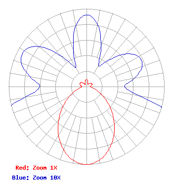 | ||||||||||||||||||
| Azimuth | Ratio | Azimuth | Ratio | Azimuth | Ratio | Azimuth | Ratio | ||||||||||||
| 0 | 0.092 | 10 | 0.081 | 20 | 0.055 | 30 | 0.031 | ||||||||||||
| 40 | 0.044 | 50 | 0.065 | 60 | 0.077 | 70 | 0.076 | ||||||||||||
| 80 | 0.063 | 90 | 0.049 | 100 | 0.070 | 110 | 0.139 | ||||||||||||
| 120 | 0.242 | 130 | 0.384 | 140 | 0.543 | 150 | 0.708 | ||||||||||||
| 160 | 0.851 | 170 | 0.958 | 180 | 1.000 | 190 | 0.964 | ||||||||||||
| 200 | 0.861 | 210 | 0.721 | 220 | 0.553 | 230 | 0.392 | ||||||||||||
| 240 | 0.253 | 250 | 0.147 | 260 | 0.080 | 270 | 0.060 | ||||||||||||
| 280 | 0.074 | 290 | 0.089 | 300 | 0.092 | 310 | 0.080 | ||||||||||||
| 320 | 0.052 | 330 | 0.028 | 340 | 0.050 | 350 | 0.079 | ||||||||||||
Structure Registration Number 1218195 Structure Type: TOWER Registered To: Crown Castle PR LLC Structure Address: Terrenos De Rafael Fuster Guayama, PR County Name: Guayama Municipio ASR Issued: 05/05/2016 Date Built: 03/27/2003 Site Elevation: 236.5 m (776 ft.) Structure Height: 60.1 m (197 ft.) Height Overall: 60.7 m (199 ft.) Overall Height AMSL: 297.2 m (975 ft.) FAA Determination: 04/07/2010 FAA Study #: 2010-ASO-1585-OE Paint & Light FAA Chapters: NONE PRIOR STUDY 2009-ASO-5774-OE 17-59-28.0 N 66-06-23.7 W (NAD 83) 17-59-35.1 N 66-06-25.1 W (Converted to NAD 27) |
Po Box 4956 Pmb 2024 Caguas, PR 00726 Phone: 787-223-4562 OWNER | Title: Owner Date: 03/04/2019 Application Certifier RAMON A HERNANDEZ Ramon A Hernandez Po Box 4956 Pmb 2024 Caguas, PR 00726 Applicant GRAFTON OLIVERA OLIVERA Grafton Olivera 5119 60th Drive E Bradenton, FL 34203 LEE J PELTZMAN J PELTZMAN Shainis & Peltzman Chartered 1850 M Street Nw Suite #240 Washington, DC 20036 | |||||||||||||||||