
FCCInfo.com
A Service of Cavell, Mertz & Associates, Inc.
(855) FCC-INFO
|
|
|
Post-repack Channel 21 Virtual Channel 38 |
|
||||||||||||||||
|
|
Repacking Information: Pre-Repack Channel: 39 Post-Repack Channel: 21 Post-Repack ERP: 102 kW Phase: 2 Completion Deadline: 4/12/2019 Find nearby TV Facilities Status: License Application Accepted: 04/12/2019 License Expires: 08/01/2022 File Number: -0000071608 FCC Website Links: LMS Facility Details This Application Other KSCE Applications Including Superseded Applications Mailing Address Correspondence for KSCE Correspondence related to application -0000071608 Service Contour - Open Street Map or USGS Map (41 dBu) Service Contour - KML / Google Earth (41 dBu) Public Inspection Files Rabbit Ears Info Search for KSCE Site Location: 31-48-18.9 N 106-29-00.7 W (NAD 83) Site Location: 31-48-18.5 N 106-28-58.7 W (Converted to NAD 27) ERP: 150 kW Polarization: Horizontally polarized HAAT: 557 m (1827 ft.) Electrical Beam Tilt: 1.25 degrees R/C AGL: 91 m (299 ft.) R/C AMSL: 1799.4 m (5904 ft.) Emission Mask: Simple Site Elevation: 1708.4 m. (5605 ft.) Height Overall*: 118.3 m (388 ft.) (* As Filed In This Application, may differ from ASR Data, Below.) Directional Antenna - Antenna Make/Model: R.F. Systems RFS-16RFS(OM)-500626-SL Antenna ID: 1004831 Polarization: Horizontally polarized | ||||||||||||||||||
| Antenna Data for Antenna Id: 1004831 KSCE DT File: -0000071608 R.F. Systems - RFS-16RFS(OM)-500626-SL Service: DT Standard Pattern: N | 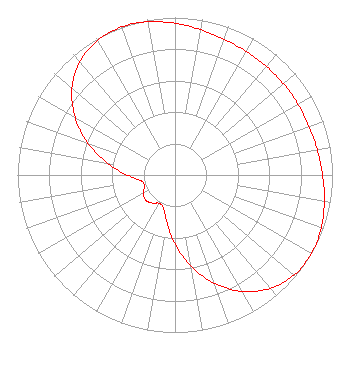 | ||||||||||||||||||
| Azimuth | Ratio | Azimuth | Ratio | Azimuth | Ratio | Azimuth | Ratio | ||||||||||||
| 0 | 0.963 | 10 | 0.937 | 20 | 0.917 | 30 | 0.905 | ||||||||||||
| 40 | 0.901 | 50 | 0.899 | 60 | 0.901 | 70 | 0.905 | ||||||||||||
| 80 | 0.917 | 90 | 0.937 | 100 | 0.963 | 110 | 0.988 | ||||||||||||
| 120 | 1.000 | 130 | 0.987 | 140 | 0.940 | 150 | 0.854 | ||||||||||||
| 160 | 0.733 | 170 | 0.589 | 180 | 0.437 | 190 | 0.302 | ||||||||||||
| 200 | 0.218 | 210 | 0.207 | 220 | 0.232 | 230 | 0.245 | ||||||||||||
| 240 | 0.232 | 250 | 0.207 | 260 | 0.218 | 270 | 0.302 | ||||||||||||
| 280 | 0.437 | 290 | 0.589 | 300 | 0.733 | 310 | 0.854 | ||||||||||||
| 320 | 0.940 | 330 | 0.987 | 340 | 1.000 | 350 | 0.988 | ||||||||||||
Structure Registration Number 1202400 Structure Type: TOWER Registered To: Pinnacle Towers LLC Structure Address: Ranger Peak El Paso, TX County Name: El Paso County ASR Issued: 05/06/2016 Date Built: 01/05/2000 Site Elevation: 1708.4 m (5605 ft.) Structure Height: 103.9 m (341 ft.) Height Overall: 118.3 m (388 ft.) Overall Height AMSL: 1826.7 m (5993 ft.) FAA Determination: 07/18/2011 FAA Study #: 2011-ASW-3190-OE FAA Circular #: 70/7460-1J Paint & Light FAA Chapters: 3, 4, 5, 13 PRIOR STUDY 2011-ASW-2910-OE 31-48-18.9 N 106-29-00.7 W (NAD 83) 31-48-18.5 N 106-28-58.7 W (Converted to NAD 27) |
2201 East Wyoming Avenue El Paso, TX 79903 Phone: 915-532-8588 Not-for-Profit | Title: Vice President And General Manager Date: 04/12/2019 Application Certifier CHANNEL 38 CHRISTIAN TELEVISION Channel 38 Christian Television 2201 East Wyoming Avenue El Paso, TX 79903 Applicant JOSEPH C CHAUTIN, III Hardy, Carey, Chautin & Balkin, Llp 1080 West Causeway Approach Mandeville, LA 70471 ESQ. MATTHEW A. SANDERFORD, JR.,P.E. Marsand, Inc. 211 Pack Saddle Trail Weatherford, TX 76088 CONSULTING ENGINEER | |||||||||||||||||
| |||||||||||||||||||