
FCCInfo.com
A Service of Cavell, Mertz & Associates, Inc.
(855) FCC-INFO
|
|
WURH-CD from 01/23/2018 WURH-CD from 11/10/2009 WURH-CD from 09/18/2001 WURH-CD from 07/07/1997 WURH-CD from 10/16/1990 |
|
|
||||||||||||||||
|
|
WURH-LD is a channel sharing guest of WPBT, Miami, Florida Status: License Application Accepted: 03/13/2019 License Expires: 02/01/2021 File Number: -0000068485 FCC Website Links: LMS Facility Details This Application Other WURH-LD Applications Including Superseded Applications Mailing Address Correspondence for WURH-LD Correspondence related to application -0000068485 Service Contour - Open Street Map or USGS Map (51 dBu) Service Contour - KML / Google Earth (51 dBu) Rabbit Ears Info Search for WURH-LD Site Location: 25-57-31.0 N 80-12-43.0 W (NAD 83) Site Location: 25-57-29.7 N 80-12-43.8 W (Converted to NAD 27) ERP: 1000 kW Polarization: Elliptically polarized HAAT: 306 m (1004 ft.) Electrical Beam Tilt: 1.0 degree R/C AGL: 306 m (1004 ft.) R/C AMSL: 307.9 m (1010 ft.) Site Elevation: 1.9 m. (6 ft.) Height Overall*: 317.9 m (1043 ft.) (* As Filed In This Application, may differ from ASR Data, Below.) Directional Antenna - Antenna Make/Model: DIELECTRIC TFU-18GTH/VP-R P250BNT Antenna ID: 1001252 Polarization: Elliptically polarized | ||||||||||||||||||
| Antenna Data for Antenna Id: 1001252 WURH-LD LD File: -0000068485 DIELECTRIC - TFU-18GTH/VP-R P250BNT Service: LD Standard Pattern: Y | 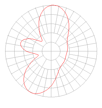 | ||||||||||||||||||
| Azimuth | Ratio | Azimuth | Ratio | Azimuth | Ratio | Azimuth | Ratio | ||||||||||||
| 0 | 0.994 | 4 | 1.000 | 10 | 0.983 | 20 | 0.896 | ||||||||||||
| 30 | 0.758 | 40 | 0.603 | 50 | 0.475 | 60 | 0.404 | ||||||||||||
| 70 | 0.379 | 80 | 0.368 | 90 | 0.354 | 100 | 0.342 | ||||||||||||
| 110 | 0.342 | 120 | 0.354 | 130 | 0.368 | 140 | 0.379 | ||||||||||||
| 150 | 0.404 | 160 | 0.475 | 170 | 0.603 | 180 | 0.758 | ||||||||||||
| 190 | 0.896 | 200 | 0.983 | 204 | 1.000 | 210 | 0.994 | ||||||||||||
| 220 | 0.913 | 230 | 0.743 | 240 | 0.508 | 250 | 0.301 | ||||||||||||
| 260 | 0.346 | 270 | 0.538 | 280 | 0.666 | 290 | 0.666 | ||||||||||||
| 300 | 0.538 | 310 | 0.346 | 320 | 0.301 | 330 | 0.508 | ||||||||||||
| 340 | 0.743 | 350 | 0.913 | ||||||||||||||||
Structure Registration Number 1029604 Structure Type: GTOWER Registered To: American Towers LLC Structure Address: 695 Nw 199th St Miami, FL County Name: Miami-Dade County ASR Issued: 03/30/2022 Date Built: 11/25/1977 Site Elevation: 1.9 m (6 ft.) Structure Height: 299.2 m (982 ft.) Height Overall: 317.9 m (1043 ft.) Overall Height AMSL: 319.8 m (1049 ft.) FAA Determination: 10/09/2014 FAA Study #: 2014-ASO-8960-OE FAA Circular #: 70/7460-1K Paint & Light FAA Chapters: 3, 4, 5, 12 25-57-31.0 N 80-12-43.0 W (NAD 83) 25-57-29.7 N 80-12-43.8 W (Converted to NAD 27) |
3401 South Congress Ave Boynton Beach, FL 33426 Phone: 305-424-4250 Not-for-Profit | Application Certifier SOUTH FLORIDA PBS, INC. South Florida Pbs, Inc. 14901 Ne 20th Ave Miami, FL 33181 Applicant Jack N. Goodman Law Offices Of Jack N Goodman 1200 New Hampshire Ave, Nw Suite 600 Washington, DC 20036 | |||||||||||||||||