
FCCInfo.com
A Service of Cavell, Mertz & Associates, Inc.
(855) FCC-INFO
|
|
WTCE-TV from 10/24/1989 WTCE-TV from 02/05/1986 |
Post-repack Channel 18 Virtual Channel 21 |
|
||||||||||||||||
|
|
Repacking Information: Pre-Repack Channel: 38 Post-Repack Channel: 18 Post-Repack ERP: 649 kW Phase: 2 Completion Deadline: 4/12/2019 Upstream/Downstream Dependencies Other Linked Stations Find nearby TV Facilities Status: License Application Accepted: 04/24/2019 License Expires: 02/01/2021 File Number: -0000072132 FCC Website Links: LMS Facility Details This Application Other WTCE-TV Applications Including Superseded Applications Mailing Address Correspondence for WTCE-TV Correspondence related to application -0000072132 Service Contour - Open Street Map or USGS Map (41 dBu) Service Contour - KML / Google Earth (41 dBu) Public Inspection Files Rabbit Ears Info Search for WTCE-TV Site Location: 27-01-32.0 N 80-10-41.9 W (NAD 83) Site Location: 27-01-30.8 N 80-10-42.7 W (Converted to NAD 27) ERP: 730 kW Polarization: Horizontally polarized HAAT: 297 m (974 ft.) Electrical Beam Tilt: 0.75 degrees R/C AGL: 295 m (968 ft.) R/C AMSL: 299.9 m (984 ft.) Site Elevation: 4.9 m. (16 ft.) Height Overall*: 311.5 m (1022 ft.) (* As Filed In This Application, may differ from ASR Data, Below.) Directional Antenna - Antenna Make/Model: Systems With Reliability Inc. SWCDT22PNS/18 Antenna ID: 1004945 Polarization: Horizontally polarized | ||||||||||||||||||
| Antenna Data for Antenna Id: 1004945 WTCE-TV DT File: -0000072132 Systems With Reliability Inc. - SWCDT22PNS/18 Service: DT Standard Pattern: N | 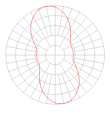 | ||||||||||||||||||
| Azimuth | Ratio | Azimuth | Ratio | Azimuth | Ratio | Azimuth | Ratio | ||||||||||||
| 0 | 0.970 | 10 | 0.880 | 20 | 0.760 | 30 | 0.620 | ||||||||||||
| 40 | 0.490 | 50 | 0.400 | 60 | 0.370 | 70 | 0.370 | ||||||||||||
| 80 | 0.370 | 90 | 0.370 | 100 | 0.370 | 110 | 0.400 | ||||||||||||
| 120 | 0.490 | 130 | 0.620 | 140 | 0.760 | 150 | 0.880 | ||||||||||||
| 160 | 0.970 | 170 | 1.000 | 180 | 0.970 | 190 | 0.880 | ||||||||||||
| 200 | 0.760 | 210 | 0.620 | 220 | 0.490 | 230 | 0.400 | ||||||||||||
| 240 | 0.370 | 250 | 0.370 | 260 | 0.370 | 270 | 0.370 | ||||||||||||
| 280 | 0.370 | 290 | 0.400 | 300 | 0.490 | 310 | 0.620 | ||||||||||||
| 320 | 0.760 | 330 | 0.880 | 340 | 0.970 | 350 | 1.000 | ||||||||||||
Structure Registration Number 1018573 Structure Type: GTOWER Registered To: American Towers LLC Structure Address: 3350 Se Bridge Rd (005020) Hobe Sound, FL County Name: Martin County ASR Issued: 05/16/2017 Date Built: 12/01/1996 Site Elevation: 4.9 m (16 ft.) Structure Height: 286.8 m (941 ft.) Height Overall: 311.5 m (1022 ft.) Overall Height AMSL: 316.4 m (1038 ft.) FAA Determination: 12/29/2010 FAA Study #: 2010-ASO-5657-OE FAA Circular #: 70/7460-1K Paint & Light FAA Chapters: 4, 7, 12 PRIOR STUDY 2007-ASO-382-OE 27-01-32.0 N 80-10-41.9 W (NAD 83) 27-01-30.8 N 80-10-42.7 W (Converted to NAD 27) |
13600 Heritage Parkway Suite 200 Fort Worth, TX 76177 Phone: 855-826-2255 Not-for-Profit | Title: Assistant Secretary Date: 04/24/2019 Application Certifier Jacksonville Educators Broadcasting, Inc. Houston, TX 77272 Applicant Kevin T. Fisher Smith & Fisher 4791 Wintergreen Court Woodbridge, VA 22192 Broadcast Consultant Coby M May Colby M. May, Esq., P.c. P. O. Box 15473 Washington, DC 20003 Attorney | |||||||||||||||||