
FCCInfo.com
A Service of Cavell, Mertz & Associates, Inc.
(855) FCC-INFO
|
|
KSKN from 06/10/1981 |
Virtual Channel 22 |  |
|
||||||||||||||||||||||||
|
|
Repacking Information: No changes Status: License Application Accepted: 04/10/2015 License Expires: 02/01/2023 File Number: -0000001266 FCC Website Links: LMS Facility Details This Application Other KSKN Applications Including Superseded Applications Mailing Address Correspondence for KSKN Correspondence related to application -0000001266 Service Contour - Open Street Map or USGS Map (41 dBu) Service Contour - KML / Google Earth (41 dBu) Public Inspection Files History Cards for KSKN Rabbit Ears Info Search for KSKN Site Location: 47-35-41.0 N 117-17-57.0 W (NAD 83) Site Location: 47-35-41.4 N 117-17-53.3 W (Converted to NAD 27) ERP: 1000 kW Polarization: Horizontally polarized HAAT: 622 m (2041 ft.) Electrical Beam Tilt: 1 degree R/C AGL: 223 m (732 ft.) R/C AMSL: 1323.0 m (4341 ft.) Site Elevation: 1100 m. (3609 ft.) Height Overall*: 286.5 m (940 ft.) (* As Filed In This Application, may differ from ASR Data, Below.) Directional Antenna - Antenna Make/Model: DIELECTRIC TFU-24DSB-E Antenna ID: 110736 Polarization: Horizontally polarized
| |||||||||||||||||||||||||||
| Antenna Data for Antenna Id: 110736 KSKN DT File: -0000001266 DIELECTRIC - TFU-24DSB-E Service: DT Standard Pattern: Y | 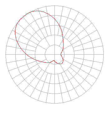 | |||||||||||||||||||||||||||
| Azimuth | Ratio | Azimuth | Ratio | Azimuth | Ratio | Azimuth | Ratio | |||||||||||||||||||||
| 0 | 0.725 | 10 | 0.590 | 20 | 0.457 | 30 | 0.346 | |||||||||||||||||||||
| 40 | 0.277 | 50 | 0.231 | 60 | 0.195 | 70 | 0.162 | |||||||||||||||||||||
| 80 | 0.137 | 90 | 0.127 | 100 | 0.139 | 110 | 0.166 | |||||||||||||||||||||
| 120 | 0.198 | 130 | 0.225 | 140 | 0.240 | 150 | 0.226 | |||||||||||||||||||||
| 160 | 0.197 | 170 | 0.164 | 180 | 0.136 | 190 | 0.128 | |||||||||||||||||||||
| 200 | 0.153 | 210 | 0.190 | 220 | 0.222 | 230 | 0.254 | |||||||||||||||||||||
| 240 | 0.301 | 250 | 0.369 | 260 | 0.459 | 270 | 0.570 | |||||||||||||||||||||
| 280 | 0.693 | 290 | 0.820 | 300 | 0.928 | 310 | 0.988 | |||||||||||||||||||||
| 320 | 1.000 | 330 | 0.995 | 340 | 0.945 | 350 | 0.848 | |||||||||||||||||||||
Structure Registration Number 1033992 Structure Type: TOWER Registered To: King Broadcasting Company Structure Address: Krell Hill 7 Mi Se Spokane, WA County Name: Spokane County ASR Issued: 02/13/2019 Date Built: 08/01/1963 Site Elevation: 1100 m (3609 ft.) Structure Height: 258.3 m (847 ft.) Height Overall: 286.5 m (940 ft.) Overall Height AMSL: 1386.5 m (4549 ft.) FAA Determination: 03/23/1990 FAA Study #: 90-ANM-0098-OE Paint & Light FAA Chapters: 1, 3, 7, 16, 21 47-35-41.0 N 117-17-57.0 W (NAD 83) 47-35-41.4 N 117-17-53.3 W (Converted to NAD 27) |
Tegna, Inc. 8350 Broad Street, Suite 2000 Tysons, VA 22102 Phone: 703-873-6606 Corporation | Title: Secretary Date: 04/10/2015 Application Certifier KSKN TELEVISION, INC. Kskn Television, Inc. Gannett Co Inc 7950 Jones Branch Dr Mclean, VA 22107 Applicant Linda R Carducci Kskn Television, Inc. Gannett Co Inc 7950 Jones Branch Dr Mclean, VA 22107 Legal Assistant Linda R Carducci Gannett Co Inc Gannett Co Inc 7950 Jones Branch Dr Mclean, VA 22107 | ||||||||||||||||||||||||||
| ||||||||||||||||||||||||||||