
FCCInfo.com
A Service of Cavell, Mertz & Associates, Inc.
(855) FCC-INFO
|
|
K34KJ-D from 02/13/2009 K34KJ-D from 03/06/1991 |
|
|
||||||||||||||||
|
|
Status: License (Licensed And Silent) Application Accepted: 08/30/2016 License Expires: 02/01/2023 File Number: -0000013881 FCC Website Links: LMS Facility Details This Application Other K34KJ-D Applications Including Superseded Applications Mailing Address Correspondence for K34KJ-D Correspondence related to application -0000013881 Service Contour - Open Street Map or USGS Map (51 dBu) Service Contour - KML / Google Earth (51 dBu) Rabbit Ears Info Search for K34KJ-D Site Location: 41-58-10.0 N 124-11-17.0 W (NAD 83) Site Location: 41-58-10.6 N 124-11-12.7 W (Converted to NAD 27) ERP: 1.62 kW Polarization: Horizontally polarized Electrical Beam Tilt: 2.5 degrees R/C AGL: 42.7 m (140 ft.) R/C AMSL: 332 m (1089 ft.) Emission Mask: Simple Site Elevation: 289.3 m. (949 ft.) Height Overall*: 48.8 m (160 ft.) (* As Filed In This Application, may differ from ASR Data, Below.) Directional Antenna - Antenna Make/Model: Scala Two CL-1469B Antenna ID: 1001009 Polarization: Horizontally polarized | ||||||||||||||||||
| Antenna Data for Antenna Id: 1001009 K34KJ-D LD File: -0000013881 Scala - Two CL-1469B Service: LD Standard Pattern: N Pattern and Field Values Include a 320° Clockwise Rotation | 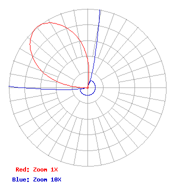 | ||||||||||||||||||
| Azimuth | Ratio | Azimuth | Ratio | Azimuth | Ratio | Azimuth | Ratio | ||||||||||||
| 0 | 0.361 | 10 | 0.086 | 20 | 0.010 | 30 | 0.010 | ||||||||||||
| 40 | 0.010 | 50 | 0.010 | 60 | 0.010 | 70 | 0.010 | ||||||||||||
| 80 | 0.010 | 90 | 0.010 | 100 | 0.010 | 110 | 0.010 | ||||||||||||
| 120 | 0.010 | 130 | 0.010 | 140 | 0.010 | 150 | 0.010 | ||||||||||||
| 160 | 0.010 | 170 | 0.010 | 180 | 0.010 | 190 | 0.010 | ||||||||||||
| 200 | 0.010 | 210 | 0.010 | 220 | 0.010 | 230 | 0.010 | ||||||||||||
| 240 | 0.010 | 250 | 0.010 | 260 | 0.010 | 270 | 0.086 | ||||||||||||
| 280 | 0.361 | 290 | 0.622 | 300 | 0.812 | 310 | 0.947 | ||||||||||||
| 320 | 1.000 | 330 | 0.947 | 340 | 0.812 | 350 | 0.622 | ||||||||||||
Structure Registration Number 1007376 Structure Type: LTOWER Registered To: UNITED STATES CELLULAR CORPORATION Structure Address: 14 Mi N Crescent City, CA County Name: Del Norte County ASR Issued: 12/30/2023 Date Built: 01/06/1997 Site Elevation: 289.3 m (949 ft.) Structure Height: 45.7 m (150 ft.) Height Overall: 48.8 m (160 ft.) Overall Height AMSL: 338.1 m (1109 ft.) FAA Determination: 11/10/2022 FAA Study #: 2022-AWP-1697-OE Paint & Light FAA Chapters: NONE 41-58-10.4 N 124-11-16.3 W (NAD 83) 41-58-11.0 N 124-11-12.0 W (Converted to NAD 27) |
P. O. Box 1489 Medford, OR 97501 Phone: 541-779-5555 Corporation | Title: President Date: 08/30/2016 Application Certifier California Oregon Broadcasting, Inc. P. O. Box 1489 Medford, OR 97501 Applicant Kathleen A. Kirby Wiley Rein Llp 1776 K Street, Nw Washington, DC 20006 Attorney | |||||||||||||||||