
FCCInfo.com
A Service of Cavell, Mertz & Associates, Inc.
(855) FCC-INFO
|
|
W32CV-D from 01/23/2004 |
|
|
||||||||||||||||
|
|
Status: License Application Accepted: 11/03/2016 License Expires: 10/01/2021 File Number: -0000016623 FCC Website Links: LMS Facility Details This Application Other W32CV-D Applications Including Superseded Applications Mailing Address Correspondence for W32CV-D Correspondence related to application -0000016623 Service Contour - Open Street Map or USGS Map (51 dBu) Service Contour - KML / Google Earth (51 dBu) Rabbit Ears Info Search for W32CV-D Site Location: 46-26-28.0 N 90-11-27.0 W (NAD 83) Site Location: 46-26-28.2 N 90-11-26.4 W (Converted to NAD 27) ERP: 8.45 kW Polarization: Horizontally polarized Electrical Beam Tilt: 1.0 degree R/C AGL: 106.7 m (350 ft.) R/C AMSL: 612.7 m (2010 ft.) Emission Mask: Full Service Site Elevation: 506 m. (1660 ft.) Height Overall*: 129.5 m (425 ft.) (* As Filed In This Application, may differ from ASR Data, Below.) Directional Antenna - Antenna Make/Model: DIELECTRIC TLP16-B Antenna ID: 19128 Polarization: Horizontally polarized
| ||||||||||||||||||
| Antenna Data for Antenna Id: 19128 W32CV-D LD File: -0000016623 DIELECTRIC - TLP16-B Service: LD Standard Pattern: Y Pattern and Field Values Include a 75° Clockwise Rotation | 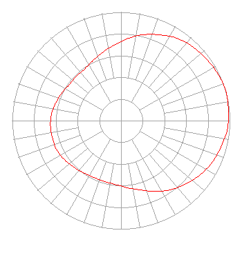 | ||||||||||||||||||
| Azimuth | Ratio | Azimuth | Ratio | Azimuth | Ratio | Azimuth | Ratio | ||||||||||||
| 5 | 0.760 | 15 | 0.820 | 25 | 0.870 | 35 | 0.920 | ||||||||||||
| 45 | 0.950 | 55 | 0.970 | 65 | 0.990 | 75 | 1.000 | ||||||||||||
| 85 | 0.990 | 95 | 0.980 | 105 | 0.950 | 115 | 0.920 | ||||||||||||
| 125 | 0.880 | 135 | 0.830 | 145 | 0.780 | 155 | 0.720 | ||||||||||||
| 165 | 0.660 | 175 | 0.620 | 185 | 0.590 | 195 | 0.580 | ||||||||||||
| 205 | 0.580 | 215 | 0.590 | 225 | 0.610 | 235 | 0.630 | ||||||||||||
| 245 | 0.650 | 255 | 0.650 | 265 | 0.650 | 275 | 0.640 | ||||||||||||
| 285 | 0.620 | 295 | 0.600 | 305 | 0.580 | 315 | 0.580 | ||||||||||||
| 325 | 0.580 | 335 | 0.610 | 345 | 0.650 | 355 | 0.700 | ||||||||||||
Structure Registration Number 1064395 [ASR Heights Differ from W32CV-D Application] Structure Type: GTOWER Registered To: Nsight Tower Holdings, LLC Structure Address: 133 Germania St Hurley, WI County Name: Iron County ASR Issued: 06/11/2020 Date Built: 02/04/1999 Site Elevation: 508.4 m (1668 ft.) Structure Height: 129.5 m (425 ft.) Height Overall: 129.5 m (425 ft.) Overall Height AMSL: 637.9 m (2093 ft.) FAA Determination: 10/26/2016 FAA Study #: 2016-AGL-14257-OE FAA Circular #: 70/7460-1J Paint & Light FAA Chapters: 4, 8, 13 PRIOR STUDY 1999-AGL-3574-OE 46-26-29.9 N 90-11-27.0 W (NAD 83) 46-26-30.1 N 90-11-26.4 W (Converted to NAD 27) |
2750 Luberon Lane Cumming, GA 30041 Phone: 678-777-8659 Limited Liability Company | Title: Chief Operating Officer Date: 11/03/2016 Application Certifier KQDS ACQUISITION CORP. Kqds Acquisition Corp. P. O. Box 9115 Fargo, ND 58106 Applicant LEIGHTON T BROWN, ESQ. Holland & Knight Llp 800 17th Street, Nw., Suite 1100 Washington, DC 20006-3906 FCC LEGAL COUNSEL | |||||||||||||||||