
FCCInfo.com
A Service of Cavell, Mertz & Associates, Inc.
(855) FCC-INFO
|
|
K36JH-D from 03/06/2008 K36JH-D from 01/26/2004 |
|
|
||||||||||||||||
|
|
Status: License Application Accepted: 03/22/2017 License Expires: 12/01/2022 File Number: -0000022335 FCC Website Links: LMS Facility Details This Application Other K36JH-D Applications Including Superseded Applications Mailing Address Correspondence for K36JH-D Correspondence related to application -0000022335 Service Contour - Open Street Map or USGS Map (51 dBu) Service Contour - KML / Google Earth (51 dBu) Rabbit Ears Info Search for K36JH-D Site Location: 34-36-43.6 N 117-17-32.1 W (NAD 83) Site Location: 34-36-43.6 N 117-17-28.9 W (Converted to NAD 27) ERP: 4 kW Polarization: Horizontally polarized R/C AGL: 40 m (131 ft.) R/C AMSL: 1370.8 m (4497 ft.) Emission Mask: Stringent Site Elevation: 1330.8 m. (4366 ft.) Height Overall*: 59.4 m (195 ft.) (* As Filed In This Application, may differ from ASR Data, Below.) Directional Antenna - Antenna Make/Model: Kathrein 723147 Antenna ID: 109221 Polarization: Horizontally polarized | ||||||||||||||||||
| Antenna Data for Antenna Id: 109221 K36JH-D LD File: -0000022335 Kathrein - 723147 Service: LD Standard Pattern: Y | 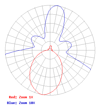 | ||||||||||||||||||
| Azimuth | Ratio | Azimuth | Ratio | Azimuth | Ratio | Azimuth | Ratio | ||||||||||||
| 0 | 0.090 | 10 | 0.100 | 20 | 0.090 | 30 | 0.060 | ||||||||||||
| 40 | 0.033 | 50 | 0.030 | 60 | 0.040 | 70 | 0.048 | ||||||||||||
| 80 | 0.048 | 90 | 0.040 | 100 | 0.038 | 110 | 0.065 | ||||||||||||
| 120 | 0.145 | 130 | 0.268 | 140 | 0.402 | 150 | 0.545 | ||||||||||||
| 160 | 0.700 | 170 | 0.845 | 180 | 0.945 | 190 | 1.000 | ||||||||||||
| 200 | 0.945 | 210 | 0.845 | 220 | 0.700 | 230 | 0.545 | ||||||||||||
| 240 | 0.403 | 250 | 0.268 | 260 | 0.145 | 270 | 0.065 | ||||||||||||
| 280 | 0.037 | 290 | 0.040 | 300 | 0.048 | 310 | 0.048 | ||||||||||||
| 320 | 0.040 | 330 | 0.030 | 340 | 0.033 | 350 | 0.060 | ||||||||||||
Structure Registration Number 1220067 Structure Type: TOWER Structure Address: 1384quartzite Mountain Oro Grande, CA County Name: San Bernardino County ASR Issued: 04/16/2002 Date Built: 11/27/2000 Site Elevation: 1330.8 m (4366 ft.) Structure Height: 59.4 m (195 ft.) Height Overall: 59.4 m (195 ft.) Overall Height AMSL: 1390.2 m (4561 ft.) FAA Determination: 04/02/2002 FAA Study #: 02-AWP-0597-OE FAA Circular #: 70/7460-1K Paint & Light FAA Chapters: 4, 5, 12 PRIOR STUDY 01-AWP-0819-OE 34-36-43.6 N 117-17-32.1 W (NAD 83) 34-36-43.6 N 117-17-28.9 W (Converted to NAD 27) |
Apple Valley, CA 92307 Phone: 760-242-1576 Individual | Title: Owner Date: 03/22/2017 Application Certifier Brent Gaddis 14848 Riverside Drive Apple Valley, CA 92307 Applicant Michael Couzens Michael Couzens , Attorney-at-law P.o. Box 3642 Oakland, CA 94609 Attorney-At-Law | |||||||||||||||||