
FCCInfo.com
A Service of Cavell, Mertz & Associates, Inc.
(855) FCC-INFO
|
|
KUWB-LD from 06/11/2003 |
|
|
||||||||||||||||
|
|
Status: Construction Permit Application Accepted: 06/01/2018 KUWB-LD CP Expires: 10/04/2021 File Number: -0000054910 FCC Website Links: LMS Facility Details This Application Other KUWB-LD Applications Including Superseded Applications Mailing Address Correspondence for KUWB-LD Correspondence related to application -0000054910 Service Contour - Open Street Map or USGS Map (51 dBu) Service Contour - KML / Google Earth (51 dBu) Rabbit Ears Info Search for KUWB-LD Site Location: 37-03-48.0 N 113-34-26.0 W (NAD 83) Site Location: 37-03-48.1 N 113-34-23.2 W (Converted to NAD 27) ERP: 0.2 kW Polarization: Horizontally polarized Electrical Beam Tilt: 1.25 degrees R/C AGL: 19 m (62 ft.) R/C AMSL: 976.6 m (3204 ft.) Emission Mask: Stringent Site Elevation: 957.6 m. (3142 ft.) Height Overall*: 28.9 m (95 ft.) (* As Filed In This Application, may differ from ASR Data, Below.) Directional Antenna - Antenna Make/Model: Andrew AL8 Antenna ID: 16352 Polarization: Horizontally polarized | ||||||||||||||||||
| Antenna Data for Antenna Id: 16352 KUWB-LD LD File: -0000054910 Andrew - AL8 Service: LD Standard Pattern: Y Pattern and Field Values Include a 110° Clockwise Rotation | 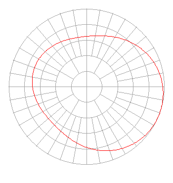 | ||||||||||||||||||
| Azimuth | Ratio | Azimuth | Ratio | Azimuth | Ratio | Azimuth | Ratio | ||||||||||||
| 0 | 0.644 | 10 | 0.662 | 20 | 0.692 | 30 | 0.733 | ||||||||||||
| 40 | 0.780 | 50 | 0.829 | 60 | 0.876 | 70 | 0.918 | ||||||||||||
| 80 | 0.953 | 90 | 0.979 | 100 | 0.995 | 110 | 1.000 | ||||||||||||
| 120 | 0.995 | 130 | 0.979 | 140 | 0.953 | 150 | 0.918 | ||||||||||||
| 160 | 0.876 | 170 | 0.829 | 180 | 0.780 | 190 | 0.733 | ||||||||||||
| 200 | 0.692 | 210 | 0.662 | 220 | 0.644 | 230 | 0.639 | ||||||||||||
| 240 | 0.646 | 250 | 0.661 | 260 | 0.678 | 270 | 0.694 | ||||||||||||
| 280 | 0.705 | 290 | 0.709 | 300 | 0.705 | 310 | 0.694 | ||||||||||||
| 320 | 0.678 | 330 | 0.661 | 340 | 0.646 | 350 | 0.639 | ||||||||||||
Structure Registration Number 1053312 [ASR Heights Differ from KUWB-LD Application] Structure Type: LTOWER Registered To: American Towers LLC Structure Address: Webb Hill - Washington County (#209530) St. George, UT County Name: Washington County ASR Issued: 03/21/2022 Date Built: 04/23/1999 Site Elevation: 951.9 m (3123 ft.) Structure Height: 27.4 m (90 ft.) Height Overall: 28.9 m (95 ft.) Overall Height AMSL: 980.8 m (3218 ft.) FAA Determination: 02/18/2022 FAA Study #: 2022-ANM-1248-OE Paint & Light FAA Chapters: NONE PRIOR STUDY 2021-ANM-4683-OE 37-03-49.3 N 113-34-25.7 W (NAD 83) 37-03-49.4 N 113-34-22.9 W (Converted to NAD 27) |
545 E. John Carpenter Freeway Suite 700 Irving, TX 75062 Phone: 972-373-8800 Corporation | Title: General Counsel Date: 06/01/2018 Application Certifier Nexstar Broadcasting, Inc. 545 E. John Carpenter Freeway Suite 700 Irving, TX 75062 Applicant Greg Best Greg Best Consulting Inc. 16100 Outlook Ave Stilwell, KS 66085 Consulting Engineer Elizabeth Ryder Nexstar Broadcasting, Inc. 545 E. John Carpenter Freeway Suite 700 Irving, TX 75062 General Counsel | |||||||||||||||||