
FCCInfo.com
A Service of Cavell, Mertz & Associates, Inc.
(855) FCC-INFO
|
|
K22MB-D from 03/08/2011 K22MB-D from 03/07/1988 |
|
|
||||||||||||||||
|
|
Status: License Application Accepted: 09/11/2018 License Expires: 02/01/2023 File Number: -0000059570 FCC Website Links: LMS Facility Details This Application Other K22MB-D Applications Including Superseded Applications Mailing Address Correspondence for K22MB-D Correspondence related to application -0000059570 Service Contour - Open Street Map or USGS Map (51 dBu) Service Contour - KML / Google Earth (51 dBu) Rabbit Ears Info Search for K22MB-D Site Location: 43-12-21.5 N 123-21-53.9 W (NAD 83) Site Location: 43-12-22.1 N 123-21-49.6 W (Converted to NAD 27) ERP: 7 kW Polarization: Horizontally polarized Electrical Beam Tilt: 1.75 degrees R/C AGL: 17 m (56 ft.) R/C AMSL: 372 m (1220 ft.) Emission Mask: Full Service Site Elevation: 355 m. (1165 ft.) Height Overall*: 20 m (66 ft.) (* As Filed In This Application, may differ from ASR Data, Below.) Directional Antenna - Antenna Make/Model: Electronics Research Inc. AL8OC-22-H Antenna ID: 1004111 Polarization: Horizontally polarized
| ||||||||||||||||||
| Antenna Data for Antenna Id: 1004111 K22MB-D LD File: -0000059570 Electronics Research Inc. - AL8OC-22-H Service: LD Standard Pattern: N | 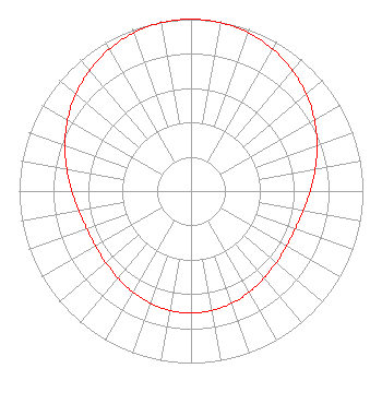 | ||||||||||||||||||
| Azimuth | Ratio | Azimuth | Ratio | Azimuth | Ratio | Azimuth | Ratio | ||||||||||||
| 0 | 1.000 | 10 | 0.995 | 20 | 0.979 | 30 | 0.953 | ||||||||||||
| 40 | 0.918 | 50 | 0.876 | 60 | 0.829 | 70 | 0.781 | ||||||||||||
| 80 | 0.734 | 90 | 0.694 | 100 | 0.663 | 110 | 0.645 | ||||||||||||
| 120 | 0.641 | 130 | 0.647 | 140 | 0.661 | 150 | 0.679 | ||||||||||||
| 160 | 0.694 | 170 | 0.705 | 180 | 0.709 | 190 | 0.705 | ||||||||||||
| 200 | 0.694 | 210 | 0.678 | 220 | 0.661 | 230 | 0.647 | ||||||||||||
| 240 | 0.641 | 250 | 0.645 | 260 | 0.663 | 270 | 0.694 | ||||||||||||
| 280 | 0.734 | 290 | 0.781 | 300 | 0.829 | 310 | 0.876 | ||||||||||||
| 320 | 0.918 | 330 | 0.953 | 340 | 0.979 | 350 | 0.995 | ||||||||||||
Structure Registration Number 1236260 Structure Type: TOWER Registered To: Oregon TV License Company, LLC KEZI(TV) Structure Address: Mount Nebo, 2.4 Km Wsw Of Roseburg, Douglas County, Oregon Roseburg, OR County Name: Douglas County ASR Issued: 08/24/2017 Date Built: 11/18/2004 Site Elevation: 355 m (1165 ft.) Structure Height: 15.2 m (50 ft.) Height Overall: 20 m (66 ft.) Overall Height AMSL: 375 m (1230 ft.) FAA Determination: 09/24/2002 FAA Study #: 2002-ANM-1750-OE Paint & Light FAA Chapters: 2 Removed expiration date from determination. Scenario 1./jjs/case#635066 43-12-21.5 N 123-21-53.9 W (NAD 83) 43-12-22.1 N 123-21-49.6 W (Converted to NAD 27) |
300 Interstate N. Parkway Atlanta, GA 30339 Phone: 770-226-2000 Limited Liability Company | Title: Ceo Date: 09/11/2018 Application Certifier Oregon Tv License Company, Llc 3282 Northside Parkway Suite 275 Atlanta, GA 30327 Applicant John M. Burgett, Esq Wiley Rein Llp 1776 K Street, N.w. Washington, DC 20006 Joseph M. Davis, P.E. Chesapeake Rf Consultants, Llc 207 Old Dominion Road Yorktown, VA 23692 CONSULTING ENGINEER | |||||||||||||||||