
FCCInfo.com
A Service of Cavell, Mertz & Associates, Inc.
(855) FCC-INFO
|
|
K16LT-D from 12/17/2018 K16LT-D from 03/16/2007 |
|
|
||||||||||||||||
|
|
Status: License Application Accepted: 12/13/2018 License Expires: 10/03/2022 File Number: -0000064169 FCC Website Links: LMS Facility Details This Application Other K16LT-D Applications Including Superseded Applications Mailing Address Correspondence for K16LT-D Correspondence related to application -0000064169 Service Contour - Open Street Map or USGS Map (51 dBu) Service Contour - KML / Google Earth (51 dBu) Rabbit Ears Info Search for K16LT-D Site Location: 43-29-57.8 N 109-41-18.5 W (NAD 83) Site Location: 43-29-58.0 N 109-41-15.9 W (Converted to NAD 27) ERP: 0.3 kW Polarization: Horizontally polarized R/C AGL: 8.7 m (29 ft.) R/C AMSL: 3021 m (9911 ft.) Emission Mask: Simple Site Elevation: 3012.3 m. (9883 ft.) Height Overall*: 9.1 m (30 ft.) (* As Filed In This Application, may differ from ASR Data, Below.) Directional Antenna - Antenna Make/Model: Scala 1X1KBBU Antenna ID: 20717 Polarization: Horizontally polarized
| ||||||||||||||||||
| Antenna Data for Antenna Id: 20717 K16LT-D LD File: -0000064169 Scala - 1X1KBBU Service: LD Standard Pattern: Y Pattern and Field Values Include a 45° Clockwise Rotation | 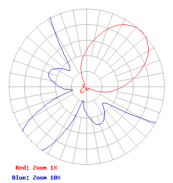 | ||||||||||||||||||
| Azimuth | Ratio | Azimuth | Ratio | Azimuth | Ratio | Azimuth | Ratio | ||||||||||||
| 5 | 0.540 | 15 | 0.700 | 25 | 0.860 | 35 | 0.960 | ||||||||||||
| 45 | 1.000 | 55 | 0.960 | 65 | 0.860 | 75 | 0.700 | ||||||||||||
| 85 | 0.540 | 95 | 0.400 | 105 | 0.270 | 115 | 0.130 | ||||||||||||
| 125 | 0.050 | 135 | 0.030 | 145 | 0.040 | 155 | 0.050 | ||||||||||||
| 165 | 0.050 | 175 | 0.040 | 185 | 0.030 | 195 | 0.020 | ||||||||||||
| 205 | 0.060 | 215 | 0.100 | 225 | 0.100 | 235 | 0.100 | ||||||||||||
| 245 | 0.060 | 255 | 0.020 | 265 | 0.030 | 275 | 0.040 | ||||||||||||
| 285 | 0.050 | 295 | 0.050 | 305 | 0.040 | 315 | 0.030 | ||||||||||||
| 325 | 0.050 | 335 | 0.130 | 345 | 0.270 | 355 | 0.400 | ||||||||||||
Structure Registration Number 1211756 Structure Type: TOWER Registered To: CENTRAL WYOMING COLLEGE dba Wyoming Public Television, KCWC-TV Structure Address: On Windy Ridge; 3.3 Mi Sw Of Dubois, Wy (inside Shoshoni Nat. Forest) Dubois, WY County Name: Fremont County ASR Issued: 04/14/2000 Date Built: 10/04/2000 Site Elevation: 3012.3 m (9883 ft.) Structure Height: 9.1 m (30 ft.) Height Overall: 9.1 m (30 ft.) Overall Height AMSL: 3021.4 m (9913 ft.) FAA Determination: 02/15/2000 FAA Study #: 00-ANM-0075-OE Paint & Light FAA Chapters: NONE 43-29-57.8 N 109-41-18.5 W (NAD 83) 43-29-58.0 N 109-41-15.9 W (Converted to NAD 27) |
2660 Peck Ave Riverton, WY 82501 Phone: 307-856-6944 Applicant | Title: General Manager Date: 12/13/2018 Application Certifier CENTRAL WYOMING COLLEGE Central Wyoming College 2660 Peck Ave Riverton, WY 82501 Applicant Lonny Fairfield Central Wyoming College 2660 Peck Avenue Riverton, WY 82501 Chief Engineer Anne Goodwin Crump Fletcher, Heald & Hildreth, P.l.c. 1300 N. 17th Street Eleventh Floor Arlington, VA 22209 Communications Counsel ERIK C SWANSON, PE Hatfield & Dawson 9500 Greenwood Ave N Seattle, WA 98103 CONSULTING ENGINEER | |||||||||||||||||