
FCCInfo.com
A Service of Cavell, Mertz & Associates, Inc.
(855) FCC-INFO
|
|
|
Post-repack Channel 32 Virtual Channel 19 |  |
|
|||||||||||||||||||||
|
|
Repacking Information: Pre-Repack Channel: 27 Post-Repack Channel: 32 Post-Repack ERP: 222 kW Phase: 2 Completion Deadline: 4/12/2019 Upstream/Downstream Dependencies Other Linked Stations Find nearby TV Facilities Status: License Application Accepted: 04/09/2019 License Expires: 08/01/2021 File Number: -0000070485 FCC Website Links: LMS Facility Details This Application Other WKPT-TV Applications Including Superseded Applications Mailing Address Correspondence for WKPT-TV Correspondence related to application -0000070485 Service Contour - Open Street Map or USGS Map (41 dBu) Service Contour - KML / Google Earth (41 dBu) Public Inspection Files History Cards for WKPT-TV Rabbit Ears Info Search for WKPT-TV Site Location: 36-25-53.0 N 82-08-15.0 W (NAD 83) Site Location: 36-25-52.6 N 82-08-15.5 W (Converted to NAD 27) ERP: 265 kW Polarization: Horizontally polarized HAAT: 711 m (2333 ft.) Electrical Beam Tilt: .75 degrees R/C AGL: 62.5 m (205 ft.) R/C AMSL: 1334.4 m (4378 ft.) Site Elevation: 1271.9 m. (4173 ft.) Height Overall*: 68.8 m (226 ft.) (* As Filed In This Application, may differ from ASR Data, Below.) Directional Antenna - Antenna Make/Model: DIELECTRIC TLP-16E Antenna ID: 69109 Polarization: Horizontally polarized | ||||||||||||||||||||||||
| Antenna Data for Antenna Id: 69109 WKPT-TV DT File: -0000070485 DIELECTRIC - TLP-16E Service: DT Standard Pattern: Y | 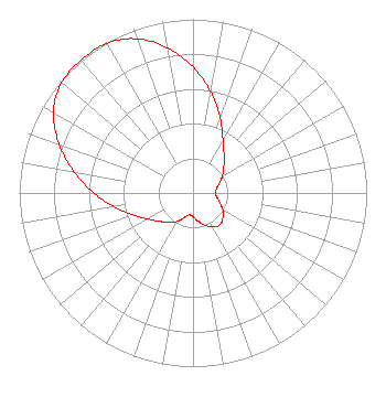 | ||||||||||||||||||||||||
| Azimuth | Ratio | Azimuth | Ratio | Azimuth | Ratio | Azimuth | Ratio | ||||||||||||||||||
| 0 | 0.725 | 10 | 0.590 | 20 | 0.457 | 30 | 0.346 | ||||||||||||||||||
| 40 | 0.277 | 50 | 0.231 | 60 | 0.195 | 70 | 0.162 | ||||||||||||||||||
| 80 | 0.137 | 90 | 0.127 | 100 | 0.139 | 110 | 0.166 | ||||||||||||||||||
| 120 | 0.198 | 130 | 0.225 | 140 | 0.240 | 150 | 0.226 | ||||||||||||||||||
| 160 | 0.197 | 170 | 0.164 | 180 | 0.136 | 190 | 0.128 | ||||||||||||||||||
| 200 | 0.153 | 210 | 0.190 | 220 | 0.222 | 230 | 0.254 | ||||||||||||||||||
| 240 | 0.301 | 250 | 0.369 | 260 | 0.459 | 270 | 0.570 | ||||||||||||||||||
| 280 | 0.693 | 290 | 0.820 | 300 | 0.928 | 310 | 0.988 | ||||||||||||||||||
| 320 | 1.000 | 330 | 0.995 | 340 | 0.945 | 350 | 0.848 | ||||||||||||||||||
Structure Registration Number 1054538 Structure Type: TOWER Registered To: HOLSTON VALLEY BROADCASTING CORPORATION Structure Address: 6247 Panhandle Road Hunter, TN County Name: Carter County ASR Issued: 08/06/1998 Date Built: 10/01/1994 Site Elevation: 1271.9 m (4173 ft.) Structure Height: 51.6 m (169 ft.) Height Overall: 68.8 m (226 ft.) Overall Height AMSL: 1340.7 m (4399 ft.) FAA Determination: 07/14/1998 FAA Study #: 98-ASO-2328-OE FAA Circular #: 70/7460-1J Paint & Light FAA Chapters: 3, 4, 5, 13 36-25-53.0 N 82-08-15.0 W (NAD 83) 36-25-52.6 N 82-08-15.5 W (Converted to NAD 27) |
222 Commerce Street Kingsport, TN 37660 Phone: 423-723-6134 Corporation | Title: President Date: 04/09/2019 Application Certifier HOLSTON VALLEY BROADCASTING CORPORATION Holston Valley Broadcasting Corporation 222 Commerce Street Kingsport, TN 37660 Applicant Darryl K DeLawder Delawder Communications, Inc. Ashburn, VA 20146 President Dennis J Kelly Law Office Of Dennis J. Kelly Post Office Box 41177 Washington, DC 20018 | |||||||||||||||||||||||
| |||||||||||||||||||||||||