
FCCInfo.com
A Service of Cavell, Mertz & Associates, Inc.
(855) FCC-INFO
|
|
|
Virtual Channel 26 |
|
||||||||||||||||
|
|
Status: Construction Permit Application Accepted: 08/11/2009 WETA-TV CP Expires: 10/01/2020 File Number: BDRTEDT-20090811ACE Prefix Type: This is BDRTEDT FCC Website Links: LMS Facility Details This Application Other WETA-TV Applications Including Superseded Applications Mailing Address Correspondence for WETA-TV Correspondence related to application BDRTEDT-20090811ACE Service Contour - Open Street Map or USGS Map (51 dBu) Service Contour - KML / Google Earth (51 dBu) History Cards for WETA-TV Rabbit Ears Info Search for WETA-TV Site Location: 39-09-27.0 N 77-29-06.0 W (NAD 83) Site Location: 39-09-26.6 N 77-29-07.0 W (Converted to NAD 27) ERP: 15 kW Electrical Beam Tilt: 0.75 degrees R/C AGL: 58.9 m (193 ft.) R/C AMSL: 190 m (623 ft.) Emission Mask: Stringent Site Elevation: 131.1 m. (430 ft.) Height Overall*: 70.1 m (230 ft.) (* As Filed In This Application, may differ from ASR Data, Below.) Directional Antenna - Antenna Make/Model: Electronics Research Inc. ATW15HS3-HSP4-31H Antenna ID: 94522 | ||||||||||||||||||
| Antenna Data for Antenna Id: 94522 WETA-TV LD File: BDRTEDT-20090811ACE Electronics Research Inc. - ATW15HS3-HSP4-31H Service: LD Standard Pattern: Y | 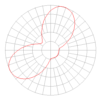 | ||||||||||||||||||
| Azimuth | Ratio | Azimuth | Ratio | Azimuth | Ratio | Azimuth | Ratio | ||||||||||||
| 0 | 0.872 | 10 | 0.977 | 17 | 1.000 | 20 | 0.997 | ||||||||||||
| 30 | 0.946 | 40 | 0.828 | 50 | 0.663 | 60 | 0.479 | ||||||||||||
| 70 | 0.312 | 80 | 0.202 | 90 | 0.184 | 100 | 0.181 | ||||||||||||
| 110 | 0.185 | 120 | 0.190 | 130 | 0.193 | 140 | 0.190 | ||||||||||||
| 150 | 0.185 | 160 | 0.181 | 170 | 0.184 | 180 | 0.202 | ||||||||||||
| 190 | 0.312 | 200 | 0.479 | 210 | 0.663 | 220 | 0.828 | ||||||||||||
| 230 | 0.946 | 240 | 0.997 | 250 | 0.977 | 260 | 0.872 | ||||||||||||
| 270 | 0.710 | 280 | 0.536 | 290 | 0.382 | 300 | 0.282 | ||||||||||||
| 310 | 0.247 | 320 | 0.282 | 330 | 0.382 | 340 | 0.536 | ||||||||||||
| 350 | 0.710 | ||||||||||||||||||
Structure Registration Number 1061796 [ASR Heights Differ from WETA-TV Application] Structure Type: LTOWER Registered To: Tower Road, LLC Structure Address: 18500 Elmers School Road Dickerson/poolesvill, MD County Name: Montgomery County ASR Issued: 09/12/2019 Date Built: 01/11/2018 Site Elevation: 125.9 m (413 ft.) Structure Height: 76.8 m (252 ft.) Height Overall: 76.8 m (252 ft.) Overall Height AMSL: 202.7 m (665 ft.) FAA Determination: 09/11/2019 FAA Study #: 2018-AEA-1068-OE FAA Circular #: 70/7460-1L Paint & Light FAA Chapters: 3, 4, 5, 12 PRIOR STUDY 2001-AEA-600-OE 39-09-26.5 N 77-29-07.4 W (NAD 83) 39-09-26.1 N 77-29-08.4 W (Converted to NAD 27) |
3939 Campbell Avenue Arlington, VA 22206 Phone: 703-998-2600 Not-for-Profit | Date: 08/11/2009 Application Certifier GREATER WASHINGTON EDUCATIONAL TELECOMMUNICATIONS ASSN, INC 2775 S. Quincy Street Arlington, VA 22206 Applicant WILLIAM R. MEINTEL Meintel, Sgrignoli & Wallace P.o. Box 907 Warrenton, VA 20188-0907 TECHNICAL CONSULTANT MARGARET L. MILLER Dow Lohnes Pllc 1200 New Hampshire Ave Nw Suite 800 Washington, DC 20036 | |||||||||||||||||