
FCCInfo.com
A Service of Cavell, Mertz & Associates, Inc.
(855) FCC-INFO
|
|
|
|
|
||||||||||||||||
|
|
Status: License Application Accepted: 07/19/2013 License Expires: 02/01/2023 File Number: BLDTL-20130719ABV Prefix Type: This is BLDTL FCC Website Links: LMS Facility Details This Application Other K28KW-D Applications Including Superseded Applications Mailing Address Correspondence for K28KW-D Correspondence related to application BLDTL-20130719ABV Service Contour - Open Street Map or USGS Map (51 dBu) Service Contour - KML / Google Earth (51 dBu) Rabbit Ears Info Search for K28KW-D Site Location: 46-19-48.4 N 120-02-14.1 W (NAD 83) Site Location: 46-19-48.9 N 120-02-09.9 W (Converted to NAD 27) ERP: 4 kW R/C AGL: 95 m (312 ft.) R/C AMSL: 325.1 m (1067 ft.) Emission Mask: Simple Site Elevation: 230.1 m. (755 ft.) Height Overall*: 105.2 m (345 ft.) (* As Filed In This Application, may differ from ASR Data, Below.) Directional Antenna - Antenna Make/Model: Scala PR-450 ARRAY Antenna ID: 111087 | ||||||||||||||||||
| Antenna Data for Antenna Id: 111087 K28KW-D LD File: BLDTL-20130719ABV Scala - PR-450 ARRAY Service: LD Standard Pattern: Y Pattern and Field Values Include a 120° Clockwise Rotation | 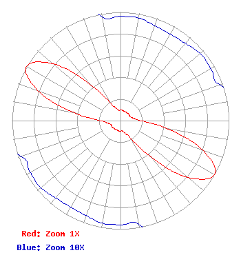 | ||||||||||||||||||
| Azimuth | Ratio | Azimuth | Ratio | Azimuth | Ratio | Azimuth | Ratio | ||||||||||||
| 0 | 0.096 | 10 | 0.096 | 20 | 0.093 | 30 | 0.092 | ||||||||||||
| 40 | 0.093 | 50 | 0.096 | 60 | 0.096 | 70 | 0.097 | ||||||||||||
| 80 | 0.125 | 90 | 0.190 | 100 | 0.447 | 110 | 0.814 | ||||||||||||
| 120 | 1.000 | 130 | 0.814 | 140 | 0.447 | 150 | 0.190 | ||||||||||||
| 160 | 0.125 | 170 | 0.097 | 180 | 0.096 | 190 | 0.096 | ||||||||||||
| 200 | 0.093 | 210 | 0.092 | 220 | 0.093 | 230 | 0.096 | ||||||||||||
| 240 | 0.096 | 250 | 0.097 | 260 | 0.125 | 270 | 0.190 | ||||||||||||
| 280 | 0.447 | 290 | 0.814 | 300 | 1.000 | 310 | 0.814 | ||||||||||||
| 320 | 0.447 | 330 | 0.190 | 340 | 0.125 | 350 | 0.097 | ||||||||||||
Structure Registration Number 1202096 Structure Type: TOWER Registered To: Centro Familiar Cristiano Structure Address: Us 12, 0.8 Miles West Sunnyside, WA County Name: Yakima County ASR Issued: 12/21/2012 Site Elevation: 230.1 m (755 ft.) Structure Height: 104.2 m (342 ft.) Height Overall: 105.2 m (345 ft.) Overall Height AMSL: 335.3 m (1100 ft.) FAA Determination: 07/29/1999 FAA Study #: 99-ANM-0985-OE Paint & Light FAA Chapters: 1, 3, 11, 21 OM&L CONTINUE PAINT/RED LIGHTS 46-19-48.4 N 120-02-14.1 W (NAD 83) 46-19-48.9 N 120-02-09.9 W (Converted to NAD 27) |
10612 15th Ave. Sw Seattle, WA 98146 Phone: 206-658-3135 Not-for-Profit | Date: 07/19/2013 Application Certifier IGLESIA PENTECOSTAL VISPERIA DEL FIN 9834 17th Ave., Sw Seattle, WA 98106 Applicant B. W. ST. CLAIR 2355 Ranch Drive Westminster, CO 80234 ENGINEERING CONSULTANT RICHARD R. ZARAGOZA, ESQ. Pillsbury Winthrop Shaw Pittman Llp | |||||||||||||||||