
FCCInfo.com
A Service of Cavell, Mertz & Associates, Inc.
(855) FCC-INFO
|
|
KRPC-LP from 02/06/2013 KRPC-LP from 07/29/1988 |
|
|
||||||||||||||||
|
|
Status: License Application Accepted: 01/30/2013 License Expires: 04/01/2022 File Number: BLDTL-20130130ADW Prefix Type: This is BLDTL FCC Website Links: LMS Facility Details This Application Other KRPC-LP Applications Including Superseded Applications Mailing Address Correspondence for KRPC-LP Correspondence related to application BLDTL-20130130ADW Service Contour - Open Street Map or USGS Map (51 dBu) Service Contour - KML / Google Earth (51 dBu) Rabbit Ears Info Search for KRPC-LP Site Location: 44-02-49.0 N 103-14-47.0 W (NAD 83) Site Location: 44-02-49.0 N 103-14-45.3 W (Converted to NAD 27) ERP: 15 kW Electrical Beam Tilt: 0.5 degrees R/C AGL: 120 m (394 ft.) R/C AMSL: 1290 m (4232 ft.) Emission Mask: Full Service Site Elevation: 1170 m. (3839 ft.) Height Overall*: 154 m (505 ft.) (* As Filed In This Application, may differ from ASR Data, Below.) Directional Antenna - Antenna Make/Model: Andrew ALP16L2-HSOC Antenna ID: 16531 | ||||||||||||||||||
| Antenna Data for Antenna Id: 16531 KRPC-LP LD File: BLDTL-20130130ADW Andrew - ALP16L2-HSOC Service: LD Standard Pattern: Y | 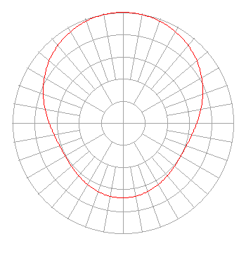 | ||||||||||||||||||
| Azimuth | Ratio | Azimuth | Ratio | Azimuth | Ratio | Azimuth | Ratio | ||||||||||||
| 0 | 1.000 | 10 | 0.994 | 20 | 0.978 | 30 | 0.951 | ||||||||||||
| 40 | 0.915 | 50 | 0.871 | 60 | 0.820 | 70 | 0.767 | ||||||||||||
| 80 | 0.715 | 90 | 0.668 | 100 | 0.631 | 110 | 0.609 | ||||||||||||
| 120 | 0.602 | 130 | 0.608 | 140 | 0.623 | 150 | 0.642 | ||||||||||||
| 160 | 0.659 | 170 | 0.672 | 180 | 0.676 | 190 | 0.672 | ||||||||||||
| 200 | 0.659 | 210 | 0.642 | 220 | 0.623 | 230 | 0.608 | ||||||||||||
| 240 | 0.602 | 250 | 0.609 | 260 | 0.631 | 270 | 0.668 | ||||||||||||
| 280 | 0.715 | 290 | 0.767 | 300 | 0.820 | 310 | 0.871 | ||||||||||||
| 320 | 0.915 | 330 | 0.951 | 340 | 0.978 | 350 | 0.994 | ||||||||||||
Structure Registration Number 1042159 [ASR Heights Differ from KRPC-LP Application] Structure Type: GTOWER Registered To: HomeSlice Media Group, LLC Structure Address: W Of Tower Rd & Skyline Dr Jct Rapid City, SD County Name: Pennington County ASR Issued: 09/08/2023 Date Built: 09/14/2023 Site Elevation: 1169.5 m (3837 ft.) Structure Height: 152.6 m (501 ft.) Height Overall: 153.6 m (504 ft.) Overall Height AMSL: 1323.1 m (4341 ft.) FAA Determination: 08/25/2023 FAA Study #: 2023-AGL-15261-OE FAA Circular #: 70/7460-1M Paint & Light FAA Chapters: 4, 8, 15 PRIOR STUDY 1998-AGL-1155-OE 44-02-48.9 N 103-14-46.6 W (NAD 83) 44-02-48.9 N 103-14-44.9 W (Converted to NAD 27) |
Chattanooga, TN 37401 Phone: 423-468-5100 Limited Liability Company | Date: 01/30/2013 Application Certifier DIGITAL NETWORKS-MIDWEST, LLC Po Box 11409 Chattanooga, TN 37401 Applicant TIM HURLEY 225 E 8th Street Chattanooga, TN 37402 INSTALLATION MANAGER MARK J. COLOMBO Digital Networks-midwest, Llc | |||||||||||||||||