
FCCInfo.com
A Service of Cavell, Mertz & Associates, Inc.
(855) FCC-INFO
|
|
|
|
|
||||||||||||||||
|
|
Status: License Application Accepted: 09/30/2009 License Expires: 02/01/2023 File Number: BLDTT-20090930AKX Prefix Type: This is BLDTT FCC Website Links: LMS Facility Details This Application Other K28JV-D Applications Including Superseded Applications Mailing Address Correspondence for K28JV-D Correspondence related to application BLDTT-20090930AKX Service Contour - Open Street Map or USGS Map (51 dBu) Service Contour - KML / Google Earth (51 dBu) Rabbit Ears Info Search for K28JV-D Site Location: 19-43-45.0 N 155-01-22.0 W (NAD 83) Site Location: 19-43-55.9 N 155-01-32.0 W (Converted to NAD 27) ERP: 9.5 kW R/C AGL: 28.3 m (93 ft.) R/C AMSL: 36.8 m (121 ft.) Emission Mask: Simple Site Elevation: 8.5 m. (28 ft.) Height Overall*: 43 m (141 ft.) (* As Filed In This Application, may differ from ASR Data, Below.) Directional Antenna - Antenna Make/Model: Scala 4DR-16-2HW Antenna ID: 20732
| ||||||||||||||||||
| Antenna Data for Antenna Id: 20732 K28JV-D LD File: BLDTT-20090930AKX Scala - 4DR-16-2HW Service: LD Standard Pattern: Y Pattern and Field Values Include a 240° Clockwise Rotation | 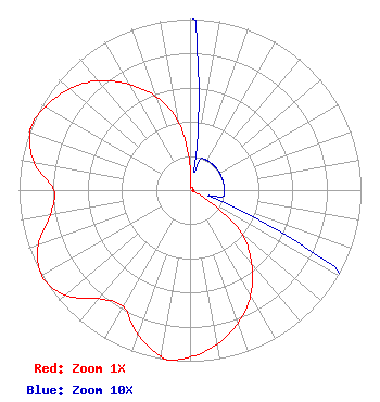 | ||||||||||||||||||
| Azimuth | Ratio | Azimuth | Ratio | Azimuth | Ratio | Azimuth | Ratio | ||||||||||||
| 0 | 0.135 | 10 | 0.020 | 20 | 0.020 | 30 | 0.020 | ||||||||||||
| 40 | 0.020 | 50 | 0.020 | 60 | 0.020 | 70 | 0.020 | ||||||||||||
| 80 | 0.020 | 90 | 0.020 | 100 | 0.020 | 110 | 0.020 | ||||||||||||
| 120 | 0.130 | 130 | 0.395 | 140 | 0.560 | 150 | 0.710 | ||||||||||||
| 160 | 0.825 | 170 | 0.915 | 180 | 0.975 | 187 | 1.000 | ||||||||||||
| 190 | 0.983 | 200 | 0.895 | 210 | 0.784 | 220 | 0.827 | ||||||||||||
| 230 | 0.955 | 240 | 1.000 | 250 | 0.945 | 260 | 0.830 | ||||||||||||
| 270 | 0.795 | 280 | 0.925 | 290 | 0.995 | 293 | 1.000 | ||||||||||||
| 300 | 0.975 | 310 | 0.920 | 320 | 0.835 | 330 | 0.715 | ||||||||||||
| 340 | 0.580 | 350 | 0.410 | ||||||||||||||||
Structure Registration Number 1026418 Structure Type: TOWER Registered To: PA MAKANI LLC dba SANDWICH ISLES WIRELESS Structure Address: Kalanianaole Ave 2.5 Mi Ne Hilo, HI County Name: Hawaii County ASR Issued: 10/22/2013 Date Built: 03/25/1997 Site Elevation: 8.5 m (28 ft.) Structure Height: 41 m (135 ft.) Height Overall: 43 m (141 ft.) Overall Height AMSL: 51.5 m (169 ft.) FAA Determination: 07/11/1997 FAA Study #: 97-AWP-1402-OE Paint & Light FAA Chapters: NONE Removed expiration date from determination. Scenario 1./jjs/case#635066 19-43-45.0 N 155-01-22.0 W (NAD 83) 19-43-55.9 N 155-01-32.0 W (Converted to NAD 27) |
Honolulu, HI 96820 Phone: 808-462-5000 Not-for-Profit | Date: 09/30/2009 Application Certifier HAWAII PUBLIC TELEVISION FOUNDATION P.o. Box 11673 Honolulu, HI 96828 Applicant STEPHEN KOMORI 2350 Dole Street Honolulu, HI 96822-2410 V.P. CONTENT DELIVERY MARGARET L. MILLER Dow Lohnes Pllc | |||||||||||||||||